California's Groundwater Bulletin 118
California’s Groundwater: Bulletin 118 Updates (CalGW Updates) are the State’s official publications on the occurrence and nature of groundwater in California. The publications define the groundwater basin boundaries and summarize groundwater information for each of the State’s 10 hydrologic regions.
CalGW Updates feature current knowledge of groundwater resources including information on the location, characteristics, use, management status, and conditions of the State’s groundwater. The publications also present findings and recommendations that support the future management and protection of groundwater.
With the passage of the Sustainable Groundwater Management Act in 2014, CalGW Updates now serve an additional role by providing important information on groundwater basins including Critical Conditions of Overdraft, Basin Boundaries, and Basin Priority. This information can help local communities, community-based organizations, local water managers, and public officials work together to create solutions for the long-term reliability of groundwater.
DWR developed a suite of California’s Groundwater (CalGW) products – linked below – that support the comprehensive CalGW Updates, including CalGW Live and CalGW Semi-Annual Updates, to improve the access and timeliness of groundwater data submitted by local agencies. CalGW Live is a web-based dashboard that utilizes many of the same data sets from the latest CalGW Update and Semi-Annual Update documents, and the California Natural Resources Agency Open Data Platform. CalGW Semi-Annual Updates are more frequent supplements to the comprehensive CalGW Updates, and also provide additional perspective on the near-real-time data availability through CalGW Live. CalGW SubsurfaceViewer, released in August 2025, provides a map view and profile view of the Statewide Airborne Electromagnetic (AEM) Survey electrical resistivity and coarse fraction data, along with lithology logs. The map view dynamically shows the exact location of AEM data displayed and utilizes data collected through the Basin Characterization Program.
NEW: The final California’s Groundwater: Bulletin 118 – Update 2025 (CalGW Update 2025) was released on March 12, 2026, after DWR incorporated public comments, which were accepted during a 45-day comment period following the draft release on October 20, 2025.
California's Groundwater Informational Resources
The final documents can be accessed below:
- Appendix A: Findings and Recommendations
- Appendix B: Glossary
- Appendix C: Methods and Assumptions
- Appendix D: Citations and Links
- Appendix E: Hydrologic Region Basin Maps with Basin Tables
- Appendix F: Water Use Data
- Appendix G: Hydrologic Region, Basin, and County Data
- Appendix H: California’s Groundwater: Semi-Annual Updates
- Appendix I: Update on Land Subsidence in California
- Appendix J: Projects and Management Actions
California’s Groundwater: Bulletin 118 – Update 2025 (CalGW Update 2025) is the State’s most up-to-date compendium of statewide data and information on groundwater resources and its management. CalGW Update 2025 consists of a summary Highlights (English, Spanish), a detailed statewide report, and a series of appendices. If you experience difficulty viewing or downloading the files, please send your request to CalGW@water.ca.gov.
Updated daily
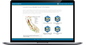
A user-friendly interactive website that allows users to explore, analyze, and visualize the latest groundwater data and information for California.
Updated twice a year
CalGW Semi-Annual Updates are more frequent supplements to the comprehensive CalGW Updates, and also provide additional perspective on the near-real-time data availability through CalGW Live.
Additional Resources
Fact sheet on California's Groundwater Update 2025 – English
Key Topics Index – quick reference to the key topics covered in California's Groundwater Update 2025
Resources in Spanish
Fact sheet on California's Groundwater Update 2025: Hoja Informativa sobre el Agua Subterránea de California - Español
DWR’s Basin Characterization Program provides valuable data and resources for understanding and managing California's groundwater on a local, regional, and statewide level. Basin Characterization Program activities are documented in California's Groundwater: Bulletin 118 Updates.

A new, user-friendly interactive website that allows users to explore and visualize a map view and profile view of the Statewide AEM Survey electrical resistivity and coarse fraction data, along with lithology logs.
Timeline of California’s Groundwater (Bulletin 118)
1956
California Department of Water Resources (DWR) established.
1975
The 93rd United States Congress passed the Safe Drinking Water Act.
1978
California Senate Bill 1505 passed. Required DWR to work with public agencies to conduct an investigation of the state’s groundwater basins and to look at patterns of groundwater pumping recharge to identify basins subject to critical conditions of overdraft.
1992
Assembly Bill 3030, the Groundwater Management Act, passed. Required formal, but voluntary groundwater management planning for the first time in California.
1999
California Legislature Budget Act of 1999 authorized funding for B-118 Update 2003 and directed DWR to complete several tasks including developing criteria for evaluation of groundwater management plans and developing a model groundwater management ordinance.
2002
Senate Bill 1938 passed. Expanded groundwater management plan requirements beyond those of Assembly Bill 3030.
2009
Senate Bill x7-6 passed: California Statewide Groundwater Elevation Monitoring (CASGEM) Program
2011
Assembly Bill 359 passed. Required that groundwater management plans map and report groundwater recharge areas.
2014
Governor Jerry Brown released initial California Water Action Plan. Set forth 10 priority actions that guide the state’s effort to create more resilient, reliable water systems and to restore critical ecosystems.
2014
The Sustainable Groundwater Management Act (SGMA) signed into law. Provided framework for required groundwater management in medium- and high-priority basins.
2016
Governor Jerry Brown released final California Water Action Plan.
Timeline of California’s Groundwater (Bulletin 118)
1952
- Identified 286 alluvium-filled valleys believed to be basins with usable groundwater.
- Created a statewide numbering system based on the boundaries of the nine Regional Water Quality Control Boards.
1966
Bulletin 118-2 published: Evaluation of Ground Water Resources: Livermore and Sunol Valleys Appendix A: Geology
1967
Bulletin 118-1 published: Evaluation of Groundwater Resources: South San Francisco Bay Appendix A. Geology
1968
Bulletin 118-1 published: Evaluation of Groundwater Resources: South San Francisco Bay Volume 1. Fremont Study Area
1973
Bulletin 118-1 published: Evaluation of Groundwater Resources: South San Francisco Bay Volume 2. Additional Fremont Study Area
1974
Bulletin 118-2 published: Evaluation of Ground Water Resources: Livermore and Sunol Valleys
1974
Bulletin 118-3 published: Evaluation of Ground Water Resources: Sacramento County
1975
- Identified 459 groundwater basins and subbasins in California and provided summary information on basin and aquifer characteristics, groundwater use, and water quality concerns.
- Summarized technical information for 248 groundwater basins, and mapped their locations.
- Included water-bearing material, well yields in the basin, depth of water bearing zones, storage capacity, usable capacity, extent of basin development, degree of knowledge of the basin, and local groundwater-related problems.
1975
Bulletin 118-4 published: Evaluation of Ground Water Resources: Sonoma County Volume 1. Geologic and Hydrologic Data
1975
Bulletin 118-1 published: Evaluation of Groundwater Resources: South San Francisco Bay Volume 3. Northern Santa Clara County
1978
Bulletin 118-6 published: Evaluation of Ground Water Resources: Sacramento Valley
1980
- Identified 471 groundwater basins/subbasins.
- Summarized information on basin characteristics, groundwater use, and included maps of areal extent.
- Included descriptions of basin settings and boundaries for selected basins.
- Identified 11 critically overdrafted groundwater basins and four basins with "special problems."
1981
Bulletin 118-1 published: Evaluation of Groundwater Resources: South San Francisco Bay Volume 4. South Santa Clara County
1982
Bulletin 118-4 published: Evaluation of Ground Water Resources: Sonoma County Volume 2. Santa Rosa Plain
1982
Bulletin 118-4 published: Evaluation of Ground Water Resources: Sonoma County Volume 3. Petaluma Valley
1982
Bulletin 118-4 published: Evaluation of Ground Water Resources: Sonoma County Volume 4. Sonoma Valley
1983
Bulletin 118-4 published: Evaluation of Ground Water Resources: Sonoma County Volume 5. Alexander Valley and Healdsburg Area
2003
- Contained a status report on groundwater management in California and an inventory of California’s groundwater information.
- Identified 515 basins/subbasins, and listed and mapped them by hydrologic region.
- Included a map of the region groundwater development, general groundwater quality information, and changes in any basins from earlier B-118 reports. The list of critically overdrafted groundwater basins, published in the 1980 update of Bulletin 118, was not reevaluated for Update 2003.
- Included groundwater data tables for each hydrologic region, the basins/subbasins, each basin’s area, a groundwater budget based on the level of basin knowledge, maximum and average well yields (if known), types of groundwater monitoring in the basin, and average and range of total dissolved solids concentrations (if known).
- Created an online supplement to the Bulletin-118 Update 2003 text, including a GIS data file containing the basin boundaries of all 515 basins.
- Included separate text descriptions of the basins, and additional information compiled by DWR staff, such as a physical basin boundary description, hydrologic setting and hydrogeology of the basin, the degree of groundwater development in the basin, specific yields of aquifers (if known), groundwater management occurring in the basin, water quality and known issues, and references.
2013
- While not a formal Bulletin-118 document, the 2013 Groundwater Update contained the most detailed information on California's groundwater resources and additional chapters for each of the 10 hydrologic regions of California.
2016
- SGMA established the basin boundary modification process which allowed local groundwater sustainability agencies to request modifications to their basin boundaries for either scientific or jurisdictional reasons. Finalized basin boundary modifications became official when published in the 2016 Interim Bulletin-118 Update. A total of 517 basins/subbasins were identified in the 2016 Interim Update.
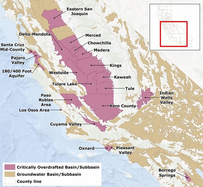
- DWR updated the methodology of analysis for conditions of critical overdraft and identified 21 critically overdrafted groundwater basins (up from 11 in 1980). The methodology and findings became official once the 2016 Interim Update was published. SGMA required critically overdrafted basins to submit groundwater sustainability plans two years earlier than high- and medium-priority basins.
2020
DWR publishes California's Groundwater Update 2020, the first Bulletin 118 five year update as required by SGMA.
2025
DWR publishes California’s Groundwater Update 2025, starting a new frequency of Bulletin 118 publications every 10 years.
Statewide Reports
Bulletin 118 statewide reports provide information about the nature and occurrence of groundwater in California with a focus on the state's groundwater basins.
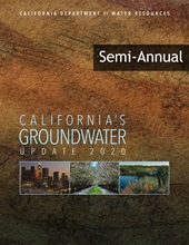
California’s Groundwater Conditions Semi-Annual Updates
Semi-annual Conditions Updates are more frequent supplements to the comprehensive 5-year CalGW Updates, and also provide additional perspective on the near-real-time data availability through CalGW Live. The semi-annual reports cover statewide groundwater elevation data changes and trends, subsidence data, well infrastructure updates, and a discussion of current concerns such as drought conditions.

California's Groundwater - Update 2025
California’s Groundwater (CalGW) Update 2025 is the State’s most up-to-date compendium of statewide data and information on groundwater resources and its management. CalGW consists of a summary Highlights (English, Spanish), a detailed Statewide Report, and a series of Appendices.
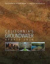
California's Groundwater - Update 2020
California’s Groundwater (CalGW) Update 2020 includes statewide data and information on groundwater resources and its management. CalGW consists of a summary Highlights (English, Spanish), a detailed Statewide Report, and a series of Appendices.
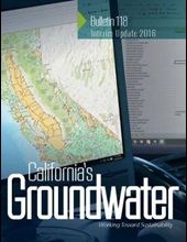
Bulletin 118 - Interim Update 2016
Update 2016 updates portions of Bulletin 118 Update 2003 and includes time-sensitive information important to implementing the new Sustainable Groundwater Management Act (SGMA). Additionally, a new procedure for basin descriptions was developed as part of the basin boundary modification process. All basins with boundary modifications in 2016 have revised basin boundary descriptions that replace their 2003 descriptions
CWP Groundwater Update 2013
California's Groundwater Update 2013: A Compilation of Enhanced Content for California Water Plan Update 2013 compiles and analyzes readily-available groundwater information to characterize California’s groundwater basins, aquifers, and well infrastructure.
Bulletin 118 - Update 2003
Update 2003 is the most recent comprehensive report on groundwater. It describes California’s groundwater basins and subbasins, including basin boundaries, hydrologic and hydrogeologic summaries, groundwater storage capacity and water budget, groundwater level and quality trends, well yields, basin management, and references.
Bulletin 118-80 - Ground Water Basins in California: A Report to the Legislature in Response to Water Code Section 12924
This report, prepared under Senate Bill 1505, Chapter 601, Statutes of 1978, Section 12924 of the California Water Code, identifies the State's groundwater basins on the basis of geological and hydrological conditions and consideration of political boundary lines whenever practical. This report also contains existing general patterns of ground water pumping and ground water recharge within such basins to the extent necessary to identify basins which are subject to critical conditions of overdraft. This document is available upon request, please email sgmps@water.ca.gov.
Publish Date: Jan 01, 1980

Bulletin 118-75 - California's Ground Water
Conclusions and recommendations are presented in Chapter I. Chapter II describes groundwater as a resource. Chapter III contains tabular summaries of information for 248 of the more important ground water basins, along with maps showing their locations. It provides references to 194 of the Department of Water Resources' reports on these basins and to 185 reports of other agencies. Chapter IV discusses ground water basin protection and utilization, and Chapter V describes opportunities for basin management and desirable future studies. This document is available upon request, please email sgmps@water.ca.gov.
Publish Date: Sep 01, 1975
Ground Water Basins in California, Water Quality Investigations Report No. 3
This report identifies the areas of alluvial-fill in the State of California which may be areas of groundwater storage. It establishes a uniform name an numbering system for groundwater basins which can be expanded as new areas of storage are identified. A selected bibliography pertaining to groundwater resources in California is included. This document is available upon request, please email sgmps@water.ca.gov.
Publish Date: Nov 01, 1952
In addition to the statewide editions of Bulletin 118, DWR has published the following limited Bulletin 118 reports that focus on specific areas of the state.
Copies of all historic publications are available by request. Email sgmps@water.ca.gov.
Bulletin 118-1 - South San Francisco Bay
- Volume 1 - Fremont Study Area (Publish Date: Aug 01, 1968)
- Volume 2 - Additional Fremont Study Area (Publish Date: Aug 01, 1973)
- Volume 3 - Northern Santa Clara County (Publish Date: Dec 01, 1975)
- Volume 4 - South Santa Clara County (Publish Date: Jan 01, 2015)
- Appendix A - Geology (Publish Date: Aug 01, 1967)
Bulletin 118-2 - Livermore and Sunol Valleys
- Bulletin 118-2 - Livermore and Sunol Valleys (Publish Date: Jun 01, 1974)
- Appendix A - Geology (Publish Date: Aug 01, 1966)
Bulletin 118-3 - Sacramento County
- Bulletin 118-3 - Sacramento County (Revision Date: Apr 01, 1980) (Publish Date: Jul 01, 1974)
Bulletin 118-4 - Sonoma County
- Volume 1 - Geologic and Hydrologic Data (Publish Date: Dec 01, 1975)
- Volume 2 - Santa Rosa Plain (Publish Date: Sep 01, 1982)
- Volume 3 - Petaluma Valley (Publish Date: Jun 01, 1982)
- Volume 4 - Sonoma Valley (Publish Date: Feb 01, 1982)
- Volume 5 - Alexander Valley and Healdsburg Area (Publish Date: Jun 01, 1983)
Bulletin 118-6 - Sacramento Valley
- Bulletin 118-6 - Sacramento Valley (Publish Date: Aug 01, 1978)
In conjunction with the release of California’s Groundwater Update 2020, DWR has compiled a comprehensive list of the official basin boundary descriptions for all of California’s 515 groundwater basins. These descriptions were originally developed by DWR as part of California’s Groundwater (B-118) Update 2003 and have since been updated for some groundwater basins as a result of the 2016 and 2018 Basin Boundary Modifications.
The original basin descriptions developed for California’s Groundwater (B-118) Update 2003 also included summaries of the hydrologic and hydrogeologic setting, groundwater storage capacity and water budget, groundwater level and quality trends, well yields, basin management, and references. This additional information contained in the basin descriptions will now be referred to as “basin reports” and are still available on CNRA Open Data as part of the Bulletin 118 - Update 2003 report. DWR hopes to update and enhance basin reports for all of California’s groundwater basins in the future based on the latest available groundwater information.
Basin Boundary GIS Data on CNRA Open Data Portal
A GIS data set, containing the boundaries for each of California's groundwater basins, is available for download through the California Natural Resources Agency’s Open Data Portal. There you will be able to download the data set in many available formats, including shapefile, geodatabase containing a basin boundary feature class, GeoJSON, and KML. It should be noted that the shapefile available for download on the Open Data web site is projected in WGS84 Web Mercator.
CASGEM
![]() California Statewide Groundwater Elevation Monitoring (CASGEM) Program - collaboration between local monitoring parties and DWR to collect groundwater elevations statewide and make that information publicly available.
California Statewide Groundwater Elevation Monitoring (CASGEM) Program - collaboration between local monitoring parties and DWR to collect groundwater elevations statewide and make that information publicly available.
Data & Tools
![]() We have a long history of data collection, monitoring, and reporting. With the passage of the Sustainable Groundwater Management Act (SGMA), there is an increased need for local and state agencies and the public to easily access water data in order to make informed management decisions. Here you will find a curated set of data, interactive mapping tools, and reports which are important resources to inform sustainable groundwater management decision-making.
We have a long history of data collection, monitoring, and reporting. With the passage of the Sustainable Groundwater Management Act (SGMA), there is an increased need for local and state agencies and the public to easily access water data in order to make informed management decisions. Here you will find a curated set of data, interactive mapping tools, and reports which are important resources to inform sustainable groundwater management decision-making.
Contact Information
Northern Region
Michelle Dooley
Supervising Engineering Geologist
2440 Main Street
Red Bluff, CA 96080
530-529-7380
Michelle.Dooley@water.ca.gov
North Central Region
Bill Brewster
Senior Engineering Geologist
3500 Industrial Blvd
West Sacramento, CA 95691
916-376-9657
Bill.Brewster@water.ca.gov
South Central Region
Dane Mathis
Supervising Engineering Geologist
691 Laverne Ave, Suite 104
Fresno, CA 93727
916-820-7773
Dane.Mathis@water.ca.gov
Southern Region
Anita Regmi
Senior Engineering Geologist
770 Fairmont Ave, Suite 200
Glendale, CA 91203
(818) 429-2414
Anita.Regmi@water.ca.gov
DWR Headquarters
Please contact: sgmps@water.ca.gov