State Water Project
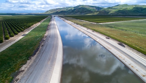
A drone provides a view of a section of the California Aqueduct within the California State Water Project, located near John R. Teerink Pumping Plant.
The California State Water Project (SWP) is a multi-purpose water storage and delivery system that extends more than 705 miles -- two-thirds the length of California. A collection of canals, pipelines, reservoirs, and hydroelectric power facilities delivers clean water to 27 million Californians, 750,000 acres of farmland, and businesses throughout our state.
Planned, built, operated and maintained by DWR, the SWP is the nation’s largest state-owned water and power generator and user-financed water system. The project is considered an engineering marvel that has helped fuel California’s population boom and economic prosperity since its initial construction.
For the last 20 years, the California State Water Project’s average water is 34 percent for agricultural and 66 percent for residential, municipal, and industrial.
The State Water Project also plays an important role in efforts to combat climate change. Not only does it help California manage its water supply during extremes such as flooding and drought, it is also a major source of hydroelectric power deliveries for the State's power grid.
Benefits of the SWP
The primary purpose of the SWP is water supply delivery and flood control, but it provides many additional benefits, including:
- Power generation
- Recreation activities
- Environmental stewardship
Planning for the Future
Now and in the future, the State Water Project will maintain its pivotal role in managing California’s water resources as we adapt to climate change. As California’s water landscape is changing, introducing new challenges, technologies, and possibilities, the SWP is dedicated in its commitment to the vision of being the most reliable, sustainable, and affordable water provider for the people and environment of California. In pursuit of this vision, the SWP has developed a risk-informed strategic approach known as “Elevate to ‘28” aimed at ensuring reliable water for the people and environment of California through 2028 and beyond. Elevate to ’28 delineates specific actions that the SWP will implement to address future challenges to secure a better future for California.
Climate change is one of the most pressing and challenging issues facing the State Water Project. Within the next 20 years, the State Water Project reliability could be reduced by as much as a quarter. The State Water Project Adaptation Strategy, a part of DWR’s three phase Climate Action Plan, describes and evaluates climate adaptation strategies the State Water Project is developing and implementing to adapt to hotter more extreme conditions in the future. The Adaptation Strategy lays out priority actions including preserving and restoring existing infrastructure, addition of the Delta Conveyance Project, Forecast Informed Reservoir Operations, and water storage facilities. Summary and supporting documentation for the strategy and a data dashboard of the Adaptation Strategy modeling are also available.
The State Water Project’s first comprehensive public facing Long-term Drought Plan is part of an expanded effort to prepare for future droughts and extreme dry conditions. Specifically, the Long-term Drought Plan includes an assessment of the potential impacts of drought on the State Water Project, including the possibility that California’s shift to a hotter, drier future may result in more severe droughts. The plan also highlights information and actions taken by the State Water Project during previous droughts, outlining how they have informed current operations and highlighting actions taken by the State Water Project to prepare for future droughts.
DWR manages the California State Water Project (SWP) to ensure adequate water supplies are available under various hydrologic and legal conditions while maintaining operational flexibility.
DWR also develops, plans and implements the operation of the SWP in coordination with environmental and regulatory agencies to meet fish, water, and environmental requirements for the Feather River and Sacramento-San Joaquin Delta.
Additionally, the SWP coordinates closely with other water storage and water users that utilize the Sacramento-San Joaquin Delta watershed. The other agency that operates in a similar fashion to move water throughout California is the federal Bureau of Reclamation’s Central Valley Project (CVP).
Learn more about DWR's operations and maintenance.
The SWP is operated in a manner that protects endangered and threatened species under the State and federal endangered species acts.
DWR does this in part through compliance with a permit granted by the California Department of Fish and Wildlife (DFW), called the Incidental Take Permit.
DWR also conducts water quality monitoring for the SWP. This program is currently managed by the Division of Operations and Maintenance, Environmental Assessment Branch. Initially, this program sought to monitor eutrophication (an increase in chemical nutrients) and salinity in the SWP. Over time, the water quality program expanded to include parameters of concern for drinking water, recreation, and wildlife.
While the majority of the SWP was being constructed in the 1960s, public agencies and local water districts signed long-term water supply contracts with DWR. Today, the 29 public agencies and local water districts are collectively known as the SWP long-term water contractors or simply, SWP water contractors.
The water supply contracts (which expire in 2035) sets forth the maximum amount of SWP water a contractor may request annually (see Table A amounts, below). However, the amount of SWP water available for delivery will vary yearly, based on a number of factors, including:
- Hydrologic conditions
- Current reservoir storage
- Delivery requests from the SWP water contractor
Learn more about State Water Project management.
To help ensure the State Water Project (SWP) can adapt to more extreme shifts in hydrology, DWR is seeking a time extension for the water rights of the SWP.
Since it was built in the 1960s, the SWP has operated under state water rights permits designed to protect water users, water quality, and fish and wildlife. Each permit issued by the State Water Board specifies, in part, the rate and amount of water that can be diverted.
California’s changing climate is resulting in more prolonged droughts punctuated by wetter periods. The State needs the flexibility to adapt its water management practices to better recover critical water supply following extreme dry conditions when the wet conditions return. The time extension for the water rights better allows for that flexibility.
DWR will complete adequate environmental documentation to support the requested time extensions in accordance with the California Environmental Quality Act (CEQA).
DWR has filed a Notice of Preparation (NOP) for the project on September 30, 2025. For more information on the NOP, visit the public notice.
Tribal Consultation & Engagement:
As part of the Water Rights Time Extension, DWR is conducting consultation with Tribal governments under CEQA Assembly Bill (AB) 52, pursuant to Public Resources Code section 21080.3.1, DWR’s Tribal Engagement Policy and the California Natural Resources Agency’s Tribal Consultation Policy. The Department is committed to a robust, collaborative, and transparent process that provides for meaningful information sharing and opportunities for input.
Initial notification letters were sent to Tribes on May 19, 2025, and a virtual pre-consultation informational meeting was scheduled for June 12, 2025, from 1:30 PM - 3:00 PM. However, DWR, postponed the June 12 meeting due to ongoing legislative proceedings that may alter the nature of the project. Postponement notifications were sent to all Tribal contacts on June 9, 2025.
For more information on the water right time extension Tribal engagement process, please contact DWR's Tribal Policy Advisor, Anecita Agustinez, at tribalpolicyadvisor@water.ca.gov.
The State Water Project fuels the growth of California’s economy. The State Water Project would be the eighth largest economy in the world between France and Italy if the State Water Project were its own nation. For more than 60 years, California’s economy has benefitted from a clean, affordable, and reliable water supply.
To learn more about how the State Water Project helps drive California’s economy, view the report and brochure outlining the report with links to appropriate sections of the report.
The State Water Project is part of the backbone of California’s infrastructure – relied on by Californians to provide not only a safe, reliable, and affordable water supply, but also flood protection for communities, environmental protection and restoration, clean energy generation, and recreational and educational opportunities.
To learn more about the benefits the State Water Project provides to California, read the “More Than Water” brochure.
Resources
- California Independent System Operator
- California Public Utilities Commission
- Federal Energy Regulatory Commission
- State Water Contractors Association
- United States Army Corps of Engineers
- U.S. Bureau of Reclamation Central Valley Project
- Western Area Power Administration
- Western Electricity Coordinating Council
- Western Systems Power Pool