Basin Prioritization

Released: May 1, 2020
Basin Prioritization is a technical process that utilizes the best available data and information to classify California’s 515 groundwater basins into one of four categories high-, medium-, low-, or very low-priority. The technical process is based on eight components that are identified in the California Water Code Section 10933(b).
Each basin’s priority determines which provisions of California Statewide Groundwater Elevation Monitoring (CASGEM) and the Sustainable Groundwater Management Act (SGMA) apply. SGMA requires medium- and high-priority basins to develop groundwater sustainability agencies (GSAs), develop groundwater sustainability plans (GSPs) and manage groundwater for long-term sustainability.
Historically, there have been two basin prioritization projects: 2014 CASGEM Basin Prioritization and SGMA 2015 Basin Prioritization. The latest basin prioritization project, SGMA 2019 Basin Prioritization, was completed in December 2019. SGMA 2019 Basin Prioritization was based on the same technical process as the previous basin prioritization efforts with minor updates to meet changes to the statute included in the SGMA legislation.
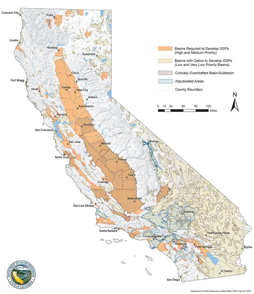
Ninety-four basins and/or sub-basins were identified as medium or high priority through the basin prioritization technical process and will be required to form GSAs and develop GSPs. These 94 basins, in combination with adjudicated areas which have existing governance and oversight in place, account for 98 percent of the pumping (20 million acre-feet), 83 percent of the population (25 million Californians), and 88 percent of all irrigated acres (6.7 million acres) within the state’s groundwater basins. Twenty-one of these basins were previously identified as Critically Overdrafted.
No future basin prioritization projects are planned at this time.
SGMA Basin Prioritization
Access the Results
The Current SGMA Basin Prioritization process and final results can be accessed below:
Frequently Asked Questions on Basin Prioritization
Answers to frequently asked questions provided below or in the Frequently Asked Questions on Basin Prioritization document.
DWR was first directed to prioritize basins as part of the Groundwater Monitoring legislation enacted in California's 2009 Comprehensive Water Package. DWR prioritized groundwater basins through the CASGEM Program and released the results in 2014.
In 2015, SGMA went into effect and required DWR to prioritize basins when basin boundaries are modified. In 2015, DWR used the 2014 CASGEM Basin Prioritization as the initial SGMA basin prioritization.
For more information on the 2014 CASGEM Basin Prioritization and SGMA 2015 Basin Prioritization Projects please email sgmps@water.ca.gov.
The Water Code requires a statewide prioritization, to the extent that data are available, of California's groundwater basins using the following eight components (Water Code §10933):
- Population
- Rate of population growth
- Number of public supply wells
- Total number of wells
- Total irrigated acreage
- Degree to which persons overlying the basin rely on groundwater as their primary source of water
- Documented impacts on the groundwater within the basin, including overdraft, subsidence, saline intrusion, and other water quality degradation
- Any other information determined to be relevant by the department, including adverse impacts on local habitat and local streamflows
Contact Us
General Inquiries:
sgmps@water.ca.gov


