
Groundwater Recharge
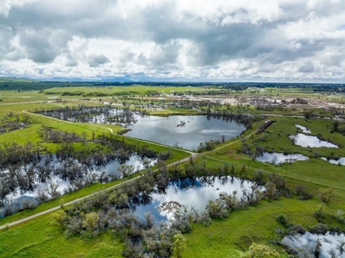
View from a drone of a groundwater recharge project at Ball Ranch near San Joaquin River in Fresno County, California. Photo taken by the Department of Water Resources March 30, 2023.
Groundwater recharge, which is the augmentation of groundwater by natural or artificial means, is a key strategy identified in the Newsom Administration’s California’s Water Supply Strategy: Adapting to a Hotter, Drier Future to expand water storage capacity and increase water resiliency through climate-driven weather extremes, including prolonged drought periods and intense storm events.
California’s groundwater basins can hold a massive amount of water – at least 850 million acre-feet, compared to the roughly 50 million acre-feet that all the major above-ground reservoirs can hold combined. These basins are vital natural infrastructure that support water supply needs throughout the state. During drier years, when there is less precipitation and snowpack to feed the rivers and fill the reservoirs, groundwater pumping accounts for up to 60 percent of the State’s total water supply. Groundwater recharge, both natural recharge occurring across the landscape and intentional recharge via human activity, is an important part of the replenishment of groundwater storage for continued use in these drier years and managing groundwater sustainably.
The Department of Water Resources’ (DWR) continues to support and expedite groundwater recharge efforts across the state. For example, DWR’s Flood-Managed Aquifer Recharge program and Flood Diversion and Recharge Enhancement Initiative are focused on supporting local recharge actions that have multiple benefits, such as flood risk reduction, groundwater recharge, drought preparedness, temporary habitat formation, etc. See below for additional details on these DWR recharge efforts and more.
Groundwater Recharge in California – A Key Water Resilience Strategy
Video also available in the following languages:
Natural Recharge - Replenishment of an aquifer generally from infiltration from precipitation, streams, and lakes and/or subsurface flow from upgradient recharge areas
Incidental recharge - The volume of water unintentionally recharged to an aquifer via human actions (such as through unlined canals or overirrigation of crops). In this context unintentional means that recharge was not a defined/intended benefit.
Baseline recharge - Replenishment resulting from precipitation and subsurface flow (see “natural recharge”) as well as unintentional, incidental recharge caused by human actions (see “incidental recharge”). This combination of natural and incidental recharge is the recharge that would happen without any additional intentional human action for recharge.
Managed Aquifer Recharge (MAR) - Water intentionally infiltrated through the vadose zone or directly injected into an aquifer for later extraction, replenishment of the aquifer, and/or long-term water resources management (like salt-water intrusion.).
Water sources for MAR come from many places. A primary source for MAR is by diverting surface water when physically and legally available (in compliance with water rights).
Capturing high flows during wet years for groundwater recharge, also referred to as Flood-Managed Aquifer Recharge (Flood-MAR), is an innovative management strategy that can provide broad benefits for Californians and ecosystems, such as flood risk reduction, water supply benefits, and ecosystem enhancements. Multi-benefit strategies like Flood-MAR can help the state adapt to a changing climate and strengthen California’s water resilience portfolio. Capturing the water when it’s available and storing it within our aquifers (California’s natural infrastructure) provides increased available supply and ecological benefits during drier years.
In addition to surface water diversions for recharge, recharge is also conducted in other important ways such as using recycled water, urban stormwater infiltration, and in-lieu recharge (using surface water or alternative water supplies when available to meet water demands in lieu of groundwater, also known as conjunctive management). See the “Current Recharge Information” section below for where to find additional information about all types and forms of recharge in California.
California has multiple pathways to divert surface water for recharge:
Existing Water Rights
Diversions for recharge could be conducted under existing standard water rights or contracts, provided the appropriate provisions are included.
Temporary Groundwater Permits
Temporary groundwater recharge permits authorize diversions of winter high flows for underground storage, including 180-day and 5-year permits. For more information, visit: State Water Resources Control Board Permits for Groundwater Recharge.
California Water Code (CWC) §1242.1 Diversions – Floodflow Diversions for Recharge
A relatively newer statutory pathway allowing for diversions for recharge without a water right or permit at times of imminent flood risk, when specific conditions are met. For more information visit: Flood Recharge Diversions (Water Code §1242.1).
Also see DWR’s Developing and Implementing an Action Under California Water Code Section 1242.1 Fact Sheet.
Flood Response Actions — Incidental Recharge
Incidental recharge (no associated water right) can occur as a result of flood response actions to protect life and property, such as the temporary storage of floodwaters in detention basins, conveyance facilities, or flood-compatible lands to attenuate peak flows.
DWR continues to support and expedite groundwater recharge efforts across the state, as described below. These coordinated actions integrate recharge into statewide water resources planning, help reduce drought-related groundwater impacts, and assist local agencies in achieving long-term sustainability under the Sustainable Groundwater Management Act (SGMA).
More information on groundwater and recharge can be found on https://water.ca.gov/Water-Basics/Groundwater. A list of groundwater recharge resources can be found on the “Groundwater Recharge Resources” tab.
California Water Watch provides the most current water conditions in California and forecasting information.
California’s Groundwater: Bulletin 118 – Update 2025 (CalGW Update 2025) provides the compendium of groundwater information and a comprehensive look at recharge in California, including methods, built and natural infrastructure, planned projects, reported recharge volumes, regulatory frameworks, and utilization strategies.
For the most up-to-date recharge volumes reported under SGMA, check out CalGW Semi-Annual Conditions Updates and CalGW Live’s Reported Recharge page.
The SGMA Data Viewer is a map-based tool with many recharge-related data layers and the up-to-date groundwater information.
The recently developed Annual Groundwater Recharge Round-Up flyer looks at volumes reported in previous water year for temporary permits, flood diversions for recharge under CWC §1242.1, and volumes reported under SGMA.
Recharge Readiness 2026 Webinar Series – DWR is co-hosting a Recharge Readiness Webinar Series with Sustainable Conservation and the Flood-MAR Network to share information about recently completed guidance, projects, and case studies to help recharge project planners and implementers (growers and local agencies, in particular) prepare for the wet season ahead. See this flyer for additional information about dates and topics.
Senate Bill (SB) 659, signed in 2023, requires DWR to, as part of the California Water Plan (CWP) 2028 and each subsequent update to the CWP, develop actionable recommendations for immediate opportunities and potential long-term solutions to advance groundwater recharge. The recommendations also call for establishing a statewide recharge knowledge base, including:
- Recharge potential of the recommendations and water availability variability
- Legal, regulatory, and financial opportunities and barriers
- Recharge locations, best practices, and implementation strategies
- Economic, water supply, and multi-benefit considerations
Senate Bill 72, signed in 2025, mandates that the California Water Plan incorporate statewide and watershed-scale planning and evaluation of adaption strategies, such as recharge, to meet water supply targets.
These two senate bills have modernized the California Water Plan toward a clear, actionable, and durable approach to statewide water planning. For more information, visit https://www.californiawaterplan.com/.
DWR is conducting robust public engagement throughout the California Water Plan development for an open, transparent process. There are many ways to Get Involved or stay updated on California Water Plan progress.
Groundwater Recharge Working Group (GRWG)
DWR is convening the Groundwater Recharge Working Group (GRWG) to support development of California Water Plan 2028 and implementation of Senate Bill 659. The GRWG brings together experts from local agencies, academia, Tribes, and organizations that are actively implementing groundwater recharge projects and informing recharge policy throughout California.
As part of California Water Plan 2028, the Working Group will provide a focused forum for practitioners and partners with groundwater recharge expertise to help inform the development of actionable recommendations and an associated body of knowledge to advance groundwater recharge throughout California. Meeting information can be found here.
Since 2018, DWR has supported various Flood-MAR efforts through tools, guidance, pilots, and studies. A few recent efforts include:
The Central Valley Flood-MAR Dashboard provides timely forecasts and local flood conditions to support flood management, emergency response, and help water agencies and diverters identify when and where excess water may be available. Expansion of this Dashboard to the Tulare Lake region is in progress.
DWR’s Watershed Studies explore opportunities to turn California’s increasingly extreme storms into long-term benefits for communities, farms and ecosystems across the state. The Watershed Studies show how using high-tech weather forecasts to inform reservoir operations can reduce flood risk, refill underground aquifers, and increase water supplies during dry times. These studies provide a basis for strategies that state, federal, and local agencies can use to better coordinate, prepare for climate extremes, and safeguard communities, farms, and ecosystems into the future.
DWR’s Flood-MAR program supported work by Sustainable Conservation to develop a package of tools and guidance to help local agencies, growers, and nonprofits plan and carry out groundwater recharge in their area. Visit Get Recharge Ready.
For more information about DWR’s Flood MAR efforts, see the FAQs and visit DWR’s Flood-MAR website.
Also see the Multi-benefit Recharge Projects for Ecosystem Enhancement flyer for additional information about multi-benefit considerations for recharge projects.
DWR’s Flood Diversion and Recharge Enhancement Initiative (FDRE) is an assistance arm of DWR’s overall Flood-MAR efforts. This assistance began in April 2023 as emergency response to the Tulare Lake emergency. DWR used one time funding to launch the Temporary Flood Diversion Equipment and Recharge Enhancement effort to help local agencies divert additional high flows to recharge areas and reduce flood risk. Working with six local partners, DWR supported rental of 30 temporary pumps and 1 siphons to move floodwater off rivers and into managed recharge sites or fields. DWR also funded over 300 acres of “Rip & Chip” land clearing to prepare agricultural lands for flood/recharge basins or be able to receive additional flood flows in the future.
Building on the 2023 emergency effort, DWR launched the Flood Diversion and Recharge Enhancement (FDRE) Initiative in December 2023 with additional one time funding, allowing the Department to support more agencies, broaden eligible activities, and provide assistance across multiple winter seasons. FDRE contracts with 14 local agencies were in place from June 2024 to June 2026 and resulted in:
- Over 32 temporary pump purchases or rented
- Multiple protective screen designs
- 600+ acres of land clearing for basin development or demand reduction
- 12 temporary basins developed
- Nearly 4 miles of conveyance improvements
These actions significantly increased local capacity to divert high flows for flood risk reduction and groundwater recharge for years to come. Additional details about this Initiative and considerations for local agencies when taking FDRE actions are available in the FDRE Brochure.
FDRE project implementation funding has been exhausted. Please fill out this FDRE Future Interest Form to express interest in assistance if future funding becomes available.
The FDRE Initiative has also been supporting recharge in other ways:
Informational materials, fact sheets, and guidance for recharge topics, such as many of resources linked above:
Community Engagement
The FDRE team is co-hosting a facilitated meetings series with the Northern California Water Association to convene water managers and recharge implementers in the Sacramento Valley to share challenges and solutions around recharge, foster regional collaboration, and develop actionable recommendations and guidance to advance diversion of floodwater and groundwater recharge in the Sacramento Valley.
WHAT’S NEXT: Although funding for project implementation actions is no longer available, the FDRE Initiative has received funding to provide technical project support to local agencies developing recharge projects, particularly those eligible for Sustainable Groundwater Management Grant Program Prop 4 funding. Additional details for this technical support are coming soon but areas of focus will be:
- Technical support for CWC §1242.1 diversions, temporary groundwater permits, and recharge project implementation
- Informational materials, guidance, resources, and tools
- Multi-benefit project support
- Watershed-level coordination, such as FIRO-MAR pilots
- Community engagement and regional collaboration support
DWR’s Basin Characterization Program is supporting recharge by completing Airborne Electromagnetic (AEM) Surveys, which collected geophysical data of all medium and high priority groundwater basins and helped characterize the subsurface geology. This data was then combined with well log and model data to develop Aquifer Recharge Potential Maps that identify areas of relative higher recharge potential for both shallow and deep aquifer recharge. These maps can be viewed on the SGMA Data Viewer. For more information, visit DWR’s Basin Characterization Program website.
DWR is conducting the Flood-MAR Water Quality Sampling Pilot to provide water quality sampling support to investigate potential water quality impacts and benefits of flooding and MAR to groundwater. In collaboration with state, federal, and local partners, this Pilot is leveraging existing wells to establish targeted water quality monitoring networks near known flooded areas and repeated managed aquifer recharge. Groundwater water quality samples and groundwater level measurements will be collected on a quarterly or semiannual basis through June 2029. Sampling began at initial sites in Fall 2025. Additional information about this effort will be added soon. For questions, please email recharge@water.ca.gov.
- Sacramento Regional Water Bank
- Omochumne Hartnell Water District
- James Irrigation District
- Consolidated Irrigation District, Recharge Basins
- Consolidated Irrigation District, "Rip and Chip"
- Fresno Irrigation District
- City of Roseville Aquifer Storage and Recovery
- Terranova Ranch
- Dunnigan Area Recharge Projects
Recharge Information and Reporting
- California Water Watch – Webpage provides the most current water conditions in California and forecasting information.
- California’s Groundwater: Bulletin 118 – Update 2025 – A compendium of groundwater and recharge information in California.
- CalGW Semi-Annual Conditions Updates – Semiannual supplement reports to the comprehensive Bulletin 118 updates, providing the most recent data and conditions.
- CalGW Live’s Reported Recharge – A live dashboard updated daily for current groundwater conditions, groundwater levels, well information, land subsidence, and SGMA reporting information – including reported MAR.
- Annual Groundwater Recharge Round-Up Flyer – The flyer looks at recharge volumes reported in the previous water year for temporary permits, flood diversions for recharge under CWC §1242.1, and volumes reported under SGMA.
Recharge Tools
-
SGMA Data Viewer – A map-based tool with many recharge-related data layers and the up-to-date groundwater information, including Aquifer Recharge Potential Maps created by DWR’s Basin Characterization Program.
-
Flood-MAR Dashboard – Provides timely statewide forecasts and local flood conditions to support flood management, emergency response, and help water agencies and diverters identify when and where excess water may be available.
Recharge Planning and Education
- Multi-benefit Recharge Projects for Ecosystem Enhancement – A flyer for additional information about multi-benefit considerations for recharge projects.
- FDRE Brochure – A flyer describing DWR’s FDRE Initiative and information for locals interested in future flood diversions for recharge actions.
- CWC §1242.1 Fact Sheet – A fact sheet describing the CWC §1242.1 requirements and general guidance for local agencies preparing for these actions.
- Sustainable Conservation’s Get Recharge Ready – DWR’s Flood-MAR program supported work by Sustainable Conservation to develop a package of tools and guidance to help local agencies, growers, and nonprofits plan and carry out groundwater recharge in their area.
Recharge Studies and Pilots
- DWR’s Watershed Studies – Regional studies that explore opportunities to turn California’s increasingly extreme storms into long-term benefits for communities, farms and ecosystems across the state.
- DWR’s Flood-MAR Program resources – DWR’s Flood-MAR program has supported multiple studies and pilots such as watershed studies, multi-benefit floodplain restoration, and Flood-MAR research and data development. Also see the Flood-MAR FAQs.
Recharge Regulations and Permitting
-
State Waterboard links:
- Flood Recharge Diversions (Water Code §1242.1) webpage – Visit this site for requirement details, current reports, and additional resources.
- CWC §1242.1 Technical Guidance
- Permits for Groundwater Recharge
- Temporary Permits for Groundwater Recharge
- Underground storage: purpose, permits, floods, importance of groundwater recharge brochure
- Flood Control, Groundwater Recharge, and Water Rights brochure
Additional Recharge Resources
- The Flood-MAR Network is a collaboration of individuals and organizations interested in promoting Flood-MAR in California. This includes state, federal, tribal, regional, and local entities; nonprofits and community-based organizations; university and private researchers; private landowners; and other stakeholders.
- The Flood-MAR Network Hub is a collection of projects, guidance, research, tools, data, and references added by the Flood-MAR Network community, containing the latest recharge-related information from a variety of organizations.
- Sustainable Conservation’s Runoff to Recharge website – Additional resources for recharge practitioners