Lake Oroville Update - February 23, 2024
A drone provides an aerial view of the California Department of Water Resources first 2024 water release from the Lake Oroville flood control gates, as water flows over the four energy dissipator blocks at the end of the Lake Oroville Main Spillway in Butte County, California. Main spillway releases will continue to manage lake levels in anticipation of rain and snowmelt. Photo taken January 31, 2024.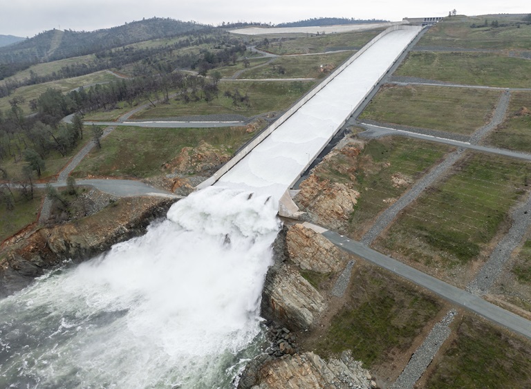
Main Spillway Releases Continue
The Department of Water Resources (DWR) is continuing water releases from Lake Oroville using the main spillway and Hyatt Powerplant. During the winter months, releases from Lake Oroville provide flood protection to downstream communities by maintaining storage capacity in the reservoir for additional rain capture and future snowmelt. DWR coordinates releases closely with the U.S. Army Corps of Engineers and other water operators and adjusts releases as needed to account for continuing runoff.
The information below reflects current reservoir level estimates. Forecasts can change quickly and may affect the estimates provided.
- Current Oroville Reservoir Level: 861 feet elevation
- Current Storage Capacity: 83 percent
- Total Releases to the Feather River: 10,000 cubic feet per second (cfs)
Total releases to the Feather River amount to 10,000 cfs with 650 cfs being routed down the low-flow channel through the City of Oroville. An additional 9,350 cfs is being released from the Thermalito Afterbay River Outlet, located 5 miles downstream from Oroville. Feather River releases may increase again in the future to account for high inflows. Feather River recreation users are advised to remain alert as river flows are expected to be swift and cold and may change based on projected weather forecasts.
Crews may also be seen working near the main spillway for several weeks. Sections of the spillway’s underdrain system are being re-inspected to capture additional video footage. In addition, crews will be performing maintenance and repairs to the spillway’s lighting system.
The Lake Oroville reservoir is the largest storage facility in the State Water Project, providing flood protection while supporting environmental and water delivery needs to 27 million Californians. In 2023, Oroville Dam’s main spillway passed over 2,370,000 acre-feet of water, 67 percent of Lake Oroville’s capacity, with flows as high as 36,000 cfs. The main spillway continues to perform well and operate as designed. DWR continues to monitor lake levels, weather forecasts, and mountain snow levels to optimize water storage while allowing for carryover storage into next year.
Oroville Dam Citizens Advisory Commission
The California Natural Resources Agency is hosting its 16th Oroville Dam Citizens Advisory Commission meeting Friday, March 1 from 10 a.m. to noon at the Southside Oroville Community Center located at 2959 Lower Wyandotte Road, Oroville, CA, 95966. The public meeting will include presentations and public comment. The Commission will receive briefings on the process DWR uses to prioritize and select Oroville facility projects, the forecast of expenditures for State Water Project activities at Oroville, and State emergency preparedness coordination and the use of weather forecasting in emergency response. The Citizens Advisory Commission is a forum for questions and feedback from the communities surrounding Oroville Dam. For more information about the meeting, please visit the Oroville Dam Citizens Advisory Commission website.
State Water Project Allocation
DWR announced on Feb. 21 an increase in the State Water Project (SWP) allocation forecast for 2024. The forecasted allocation is now 15 percent of requested supplies, up from the 10 percent initial allocation announced in December. This translates to about 200,000 acre-feet of additional water for the 29 public water agencies that serve 27 million Californians.
This assessment does not include the results of any of the storms that hit California earlier this month. The State Water Project will review conditions and may revise the forecasted allocation in mid-March. The February allocation forecast update takes into account snow survey measurements and data up until Feb.1 and spring runoff forecasts outlined in the first Bulletin 120 of the season.
More information about the allocation announcement is available in DWR’s press release.
Oroville Recreation
DWR, the California Department of Parks and Recreation (State Parks), and the California Department of Fish and Wildlife (CDFW) maintain over 92 miles of trails in the Oroville area. An interactive map of recreation facilities, including open trails and their permitted uses (hike, bike, horse, multi), is available on DWR’s Lake Oroville Recreation webpage. A paper trail map is available at various locations, including most entrance kiosks and the Lake Oroville Visitor Center.
The Lake Oroville Visitor Center is open daily from 9 a.m. to 5 p.m. Staffed by knowledgeable guides, the Visitor Center features interpretive displays on Oroville Dam, area geology, wildlife and habitat, hydroelectric power, and cultural and historical artifacts. View videos in the theater about the construction of Oroville Dam, walk or hike along nearby trails, and visit the 47-foot-tall observation tower that provides unsurpassed panoramic views of surrounding areas. Free guided tours for school and community groups are available by reservation. Parking and admission to the Visitor Center are free.
Lake Oroville is one of the State Water Project’s premier recreational destinations and one of California’s best fishing spots. The lake provides both warm-water and cold-water fisheries and is a popular destination for bass tournaments. Below the Oroville Dam, the Thermalito Afterbay and the Feather River offer additional excellent fishing opportunities. The marinas at Bidwell Canyon and Lime Saddle are open daily and provide a variety of services including a convenience store, gas, and boat rentals.
Upstream migrating fish totals between Jan. 1 and Feb. 18 are:
- Fall-run Chinook salmon: 42
- Steelhead: 675
- Data for 2023 migrating fish totals is available on CalFish.
Current Lake Operations
Lake Oroville is at 861 feet elevation and storage is approximately 2.96 million acre-feet (MAF), which is 83 percent of its total capacity and 136 percent of the historical average.
Feather River flows remain at 650 cfs through the City of Oroville with 9,350 cfs being released from the Thermalito Afterbay River Outlet (Outlet) for a total Feather River release of 10,000 cfs downstream. DWR continues to assess releases to the Feather River daily.
Visitors to Oroville Dam may also notice minor amounts of water flowing from drains built into the emergency spillway, which is normal and expected with the emergency spillway design. The dam and emergency spillway continue to operate as intended.
The public can track precipitation, snow, reservoir levels, and more at the California Data Exchange Center. The Lake Oroville gage station is identified as “ORO.”
All data as of midnight 2/22/2024.
###
Know someone who would like to receive Community Updates? They can email their request to oroville@water.ca.gov.