Lake Oroville Community Update - November 17, 2023
A drone image of water levels at West Branch Feather River Bridge along Highway 70 located at Lake Oroville in Butte County, California. On this date, the water storage was 73 percent of the total capacity. Photo taken October 2, 2023.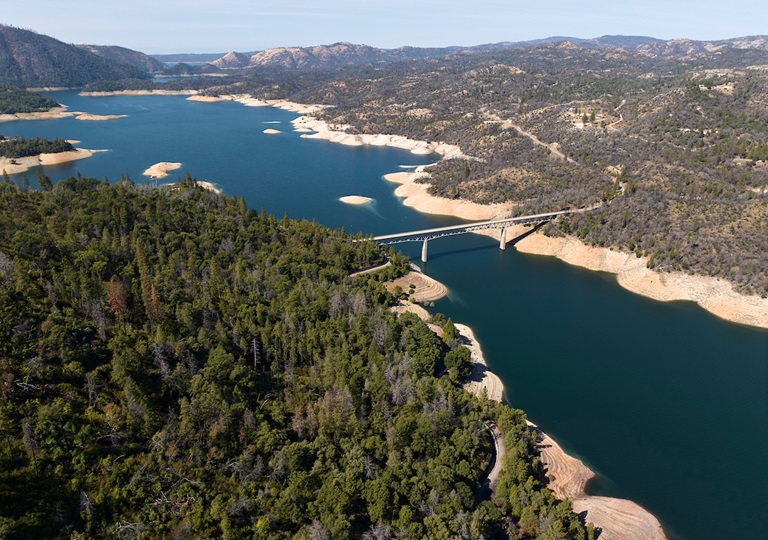
Oroville Dam Citizens Advisory Commission
The California Natural Resources Agency hosted a virtual Oroville Dam Citizens Advisory Commission meeting on Nov. 15 via Zoom. In addition to public comment, the Commission received briefings on Forecast Informed Reservoir Operations, the U.S. Army Corps of Engineers’ process to update the Water Control Manual for Oroville operations, and preparations for 2023–24 winter operations.
The Citizens Advisory Commission is a forum for questions and feedback from the communities surrounding Oroville Dam. For information on the meeting, please visit https://bit.ly/OrovilleCAC. A transcript of the meeting will be available on the webpage in the coming weeks.
Feather River Fish Monitoring Station
A Feather River Fish Monitoring Station installed by the Department of Water Resources (DWR) in Oroville continues to provide underwater video footage that allows biologists to determine abundance, run timing, and origin (hatchery or natural) of steelhead and Chinook salmon populations. This information helps improve management of these important fish populations in the Feather River and at the Feather River Fish Hatchery.
Monitoring stations like this are widely used in many rivers to collect fish population data and provide a safer and faster method of data collection, while still permitting river recreation. Whether traveling downstream or upstream, vessels of all kinds can safely navigate over the structure. DWR’s instructional video illustrates how vessels such as powerboats, drift boats, and kayaks may navigate over the fish monitoring station. Those in more portable water vessels also have the option to use the riverbank and walk around the monitoring station.
Upstream migrating fish totals between Sept. 11 and Nov. 11 are:
- Chinook salmon: 30,416
- Steelhead: 746
Feather River Fish Monitoring Station net totals are also manually updated weekly on CalFish.org.
Maintenance Work on Main Spillway Extended
Routine concrete and joint sealant repair work on localized areas of Oroville Dam’s main spillway has been extended to Dec. 1 due to favorable weather and lower reservoir levels. DWR will continue to monitor reservoir levels and weather forecasts closely and will end repair work for this season early if spillway releases are required for flood control.
Oroville Dam’s main spillway performed well and operated as designed in 2023, passing over 2,370,000 acre-feet of water – approximately 67 percent of the capacity of Lake Oroville. Due to seasonal temperature variations, spillway releases, and sun exposure, periodic concrete and joint sealant repairs of the main spillway are expected.
Work so far has included concrete repair, approximately 1,700 feet of concrete slab and wall joint sealant replacement, and inspection of the 51,000 feet of piping that support the spillway’s improved drainage system.
The spillway was rebuilt to the highest engineering and safety standards with oversight and guidance by the Federal Energy Regulatory Commission (FERC), Division of Safety of Dams (DSOD), and an independent board of consultants. DWR performed a significant amount of inspection and testing throughout construction to verify compliance with project specifications. DWR also provides regular updates to the Oroville Dam Citizens Advisory Commission.
Oroville Recreation
The Monument Hill Boat Ramp at the Thermalito Afterbay will be closed for repairs on Monday, Nov. 20. Trailered boat launch access to the Afterbay will still be available at the Wilbur Road boat ramp, while access for cartop boaters is available at the Larkin Road ramp.
The Lake Oroville Visitor Center is open seven days a week from 9 a.m. to 5 p.m. Staffed by knowledgeable guides, the Visitor Center features interpretive displays on Oroville Dam, area geology, wildlife and habitat, hydroelectric power, and cultural and historical artifacts. View videos in the theater about the construction of Oroville Dam, walk or hike along nearby trails, and visit the 47-foot-tall observation tower that provides unsurpassed panoramic views of surrounding areas. Free guided tours for school and community groups are available by reservation. Parking and admission to the Visitor Center are free.
DWR, State Parks, and the Department of Fish and Wildlife maintain over 92 miles of trails in the Oroville area. An interactive map of recreation facilities, including open trails and their permitted uses (hike, bike, horse, multi), is available on DWR’s Lake Oroville Recreation webpage. A paper trail map is available at various locations, including most entrance kiosks and the Lake Oroville Visitor Center. The marinas at Bidwell Canyon and Lime Saddle are open daily and provide a variety of services including a convenience store, gas, and boat rentals.
Current Lake Operations
Lake Oroville is at 814 feet elevation and storage is approximately 2.36 million acre-feet (MAF), which is 67 percent of its total capacity and 132 percent of the historical average.
Feather River flows remain at 650 cubic feet per second (cfs) through the City of Oroville with 1,100 cfs being released from the Thermalito Afterbay River Outlet (Outlet) for a total Feather River release of 1,750 cfs downstream. DWR continues to assess releases to the Feather River daily.
Visitors to Oroville Dam may also notice minor amounts of water flowing from drains built into the emergency spillway, which is normal and expected with the emergency spillway design. The dam and emergency spillway continue to operate as intended.
The public can track precipitation, snow, reservoir levels, and more at the California Data Exchange Center. The Lake Oroville gage station is identified as “ORO.”
All data as of midnight 11/16/2023.
DWR wishes everyone a Happy Thanksgiving.
The Lake Oroville Community Update will return on December 1, 2023.