Lake Oroville Community Update - June 30, 2023
Aerial view of Lake Oroville on June 12, 2023.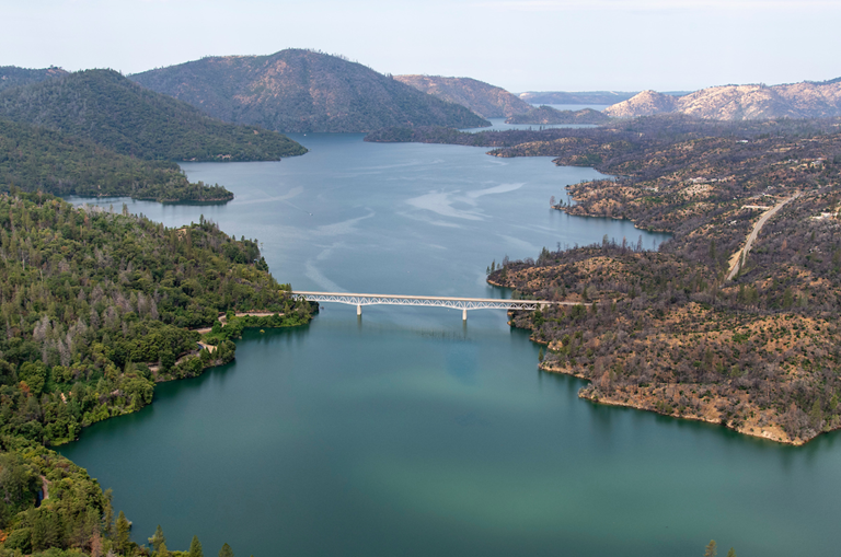
Lake Oroville Water Operations
Winter storms and spring snowmelt have filled the Lake Oroville reservoir to capacity, an increase of more than 2.5 million acre-feet of water since Dec. 1. The Department of Water Resources (DWR) continues releases from Lake Oroville through the Hyatt Powerplant and Thermalito Afterbay River Outlet. Total releases to the Feather River amount to 1,900 cubic feet per second (cfs), with adjustments being made to manage storage levels. Inflows into Lake Oroville have been declining with the shrinking snowpack. Over the past week, inflows into Lake Oroville have been in the range of 4,200 cfs to 4,800 cfs. For the coming week, inflows are projected to be in the range of 3,300 cfs to 4,200 cfs.
DWR may intermittently use the main spillway this summer for water releases to manage storage within the Oroville complex or maintain Feather River temperature levels during ongoing river valve outlet system work near the Hyatt Powerplant. When the main spillway is not in use water may still be seen on the main spillway outlet as the seals on the eight radial gates are not designed to be watertight. The gate seals do not play a role in the structural integrity of the gates, which continue to operate as intended. DWR periodically maintains and adjusts the seals during low-reservoir conditions to improve their sealing capability. The radial gates were also last inspected and tested in Dec. 2022.
Lake Oroville is full and at this level there is also the potential for some waves to splash over the crest of the emergency spillway if we experience any particularly windy days. While unlikely, DWR will be monitoring for the potential of any wave runup that might splash over the crest of the emergency spillway. Wave splash will not affect the integrity of the emergency spillway structure or Oroville Dam.
Visitors to Oroville Dam may also notice minor amounts of water flowing from drains built into the emergency spillway. As the reservoir level has increased, water flow from the drains has increased, which is normal and expected with the emergency spillway design. The dam and emergency spillway continue to operate as intended.
Driftwood and other floating debris on Lake Oroville are expected due to continued water inflows from tributaries and a high lake level, in combination with past wildfires impacting the watershed. Since January, DWR and California Department of Parks and Recreation (State Parks) staff have been collecting, containing, and pulling pieces of wood out of the lake and away from boat launch ramps using boom lines. However, boaters, water skiers, and other water recreationists should take precautions when operating boats on Lake Oroville and should remain alert for floating debris.
The Lake Oroville reservoir is the largest storage facility in the State Water Project (SWP) and supports environmental and water delivery needs to 27 million Californians and reduces flood risks to downstream communities. DWR continues to closely monitor lake levels and will adjust releases accordingly to optimize operations for water storage and environmental protection while allowing for carryover storage into next year.
Fourth of July in Oroville
Celebrate our nation’s independence on July 4 with a spectacular fireworks show at the Oroville Airport located at 225 Chuck Yeager Way. Patriotic festivities begin Saturday, July 1 with a fly-in and car show at the airport from 8 a.m. to 3 p.m. The free event includes a pancake breakfast, food vendors, art and craft vendors, remote-controlled helicopter demonstrations, airplanes, classic cars, and low riders.
On Tuesday, July 4, kick off the holiday with a meet and greet with Oroville’s first responders from 9 a.m. to 1 p.m. at the Oroville Airport. Later that evening, the Fourth of July fireworks show begins 30 minutes after sunset. The Oroville Chamber of Commerce’s website has several maps highlighting prime locations for fireworks viewing so you can plan ahead.
Oroville Dam Citizens Advisory Commission
The California Natural Resources Agency is hosting its 14th Oroville Dam Citizens Advisory Commission meeting on July 7, 10 a.m. to noon. The public meeting will be held virtually and will include presentations and public comment. The Commission will receive briefings on dam safety projects, fiscal year 2023–24 Oroville Dam facility expenditures, and ongoing conversations about inundation maps. The Citizens Advisory Commission is a forum for questions and feedback from the communities surrounding Oroville Dam. For information on how to join the virtual meeting, please visit https://bit.ly/OrovilleCAC.
Swim Beaches
The summer months have officially arrived and temperatures in Northern California are climbing. While Lake Oroville offers ample water opportunities for boating, kayaking or wakeboarding, the Lake Oroville State Recreation Area (LOSRA) and Oroville Wildlife Area (OWA) also offer several family-friendly swim beaches that are excellent locations to beat the heat.
Swim beaches within the LOSRA and OWA provide shallow wading and swimming opportunities for visitors of all ages with nearby restroom facilities. Some locations also include picnic benches and barbecue facilities that are perfect for hosting a fun family gathering. Beat the heat this summer and relax at one of our recreation facility swim beaches – Loafer Creek at Lake Oroville, Monument Hill or Larkin Road at the Thermalito Afterbay, the South Thermalito Forebay, or North Thermalito Forebay.
Oroville Recreation
The Lake Oroville Visitor Center is open Monday through Friday between 9 a.m. and 5 p.m. The Visitor Center will be closed July 4 for the holiday. The Visitor Center offers numerous educational exhibits, a theater featuring videos about the building of Oroville Dam, walking and hiking trails, and a 47-foot-tall observation tower providing unsurpassed panoramic views.
DWR, State Parks, and the California Department of Fish and Wildlife maintain over 92 miles of trails in the Oroville area. An interactive map of recreation facilities, including open boat ramps, and their permitted uses (hike, bike, horse, multi) is available on DWR’s Lake Oroville Recreation webpage. A paper trail map is available at various locations, including most entrance kiosks and the Visitor Center. The marinas at Bidwell Canyon and Lime Saddle are open daily and provide a variety of services such as a shuttle and boat rentals.
Current Lake Operations
Lake Oroville is at 898 feet elevation and storage is approximately 3.51 million acre-feet (MAF), which is 99 percent of its total capacity and 131 percent of the historical average.
The Feather River releases are at 1,900 cfs. Flows through the City of Oroville are 1,150 cfs with 850 cfs released from the Thermalito Afterbay Outlet (Outlet) for a total of 1,900 cfs downstream of the Outlet. DWR continues to assess releases to the Feather River daily.
The public can track precipitation, snow, reservoir levels, and more at the California Data Exchange Center. The Lake Oroville gage station is identified as “ORO”.
All data as of midnight 6/29/2023.