Lake Oroville Community Update - July 14, 2023
An aerial view shows high water conditions at Enterprise Bridge on Lake Oroville in Butte County, California. Photo taken July 3, 2023.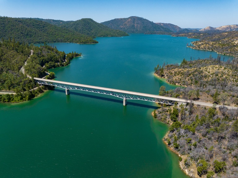
Lake Oroville Water Operations
The Department of Water Resources (DWR) continues releases from Lake Oroville to manage storage levels along with water quality and flows through the Sacramento-San Joaquin Delta. Total releases to the Feather River amount to 5,000 cubic feet per second (cfs), with adjustments being made as needed. Over the past week, inflows into Lake Oroville have been in the range of 3,600 to 4,000 cfs and are projected to be lower for the coming week.
DWR is currently using the main spillway for water releases to manage storage within the Oroville complex and maintain Feather River temperature levels during ongoing river valve outlet system work near the Hyatt Powerplant. When the main spillway is not in use water may still be seen on the main spillway outlet as the seals on the eight radial gates are not designed to be watertight. The gate seals do not play a role in the structural integrity of the gates, which continue to operate as intended. DWR periodically maintains and adjusts the seals during low-reservoir conditions to improve their sealing capability. The radial gates were also last inspected and tested in Dec. 2022.
Visitors to Oroville Dam may also notice minor amounts of water flowing from drains built into the emergency spillway. As the reservoir level has increased, water flow from the drains has increased, which is normal and expected with the emergency spillway design. The dam and emergency spillway continue to operate as intended.
Driftwood and other floating debris on Lake Oroville are expected due to continued water inflows from tributaries and a high lake level, in combination with past wildfires impacting the watershed. Since January, DWR and California Department of Parks and Recreation (State Parks) staff have been collecting, containing, and pulling pieces of wood out of the lake and away from boat launch ramps using boom lines. However, boaters, water skiers, and other water recreationists should take precautions when operating boats on Lake Oroville and should remain alert for floating debris.
The Lake Oroville reservoir is the largest storage facility in the State Water Project (SWP) and supports environmental and water delivery needs to 27 million Californians and reduces flood risks to downstream communities. DWR continues to closely monitor lake levels and will adjust releases accordingly to optimize operations for water storage and environmental protection while allowing for carryover storage into next year.
A Restorative Winter
At only 29 percent capacity in December 2022, the Lake Oroville reservoir has made an astounding recovery thanks to numerous atmospheric rivers that delivered heavy amounts of rain and snow to California this winter. Lake Oroville gained more than 2.5 million acre-feet of water after Dec. 1, bringing the reservoir to its full capacity – a marked difference in just seven months.
See the difference in water levels between Dec. 21, 2022, when the reservoir was at 29 percent capacity, to July 3, 2023, with Lake Oroville at 99 percent capacity. It’s a welcome sight!
Oroville Recreation
A full reservoir delivers numerous opportunities for water recreation at Lake Oroville and is also a prime location to beat 100-degree weather. Water enthusiasts were out in full force at Lake Oroville during the week of July 4. Whether you enjoy swimming, boating, kayaking, jet skiing, fishing, or several other water activities, don’t miss your opportunity to relax and recreate at the lake! The marinas at Bidwell Canyon and Lime Saddle are open daily and provide a variety of services such as a shuttle and boat rentals.
DWR, State Parks, and the California Department of Fish and Wildlife also maintain over 92 miles of trails in the Oroville area. An interactive map of recreation facilities, including open boat ramps, and their permitted uses (hike, bike, horse, multi) is available on DWR’s Lake Oroville Recreation webpage. A paper trail map is available at various locations, including most entrance kiosks and the Visitor Center.
The Lake Oroville Visitor Center is open Monday through Friday between 9 a.m. and 5 p.m. The Visitor Center offers numerous educational exhibits, a theater featuring videos about the building of Oroville Dam, walking and hiking trails, and a 47-foot-tall observation tower providing unsurpassed panoramic views.
Feather River Fish Monitoring Station
DWR is continuing construction activities for a fish monitoring station project in the Feather River in Oroville. The fish monitoring station will provide information on abundance, run timing, and origin (hatchery or natural) of steelhead and Chinook salmon populations that will be used to improve management of these fish populations in the lower Feather River.
Work began in June with ongoing installation of a solar panel system along the bank of the Feather River. This week, crews also began in-water work for installation of the fish monitoring station weir that will stretch across the Feather River. Installation of the structure may be complete as early as July 21, but may extend longer due to elevated water conditions in the low-flow channel.
Once installed, river users can easily pass over the floating structure using a modified passage panel. Informational signs will be posted at boat launches and near the monitoring station to assist river users in navigating over the structure. Those in more portable water vessels also have the option to use the riverbank and walk around the monitoring station.
The structure is being installed along the low-flow channel of the Feather River approximately 6.5 miles downstream of the Feather River Fish Hatchery, 4.5 miles downstream of the Riverbend Boat Ramp, and 1.5 miles upstream of the Thermalito Afterbay River Outlet Boat Ramp.
Camping at Lake Oroville
The summer months invite everyone to get outside and enjoy the benefits of longer daylight hours. However, summer heat can make recreating outdoors tiring, which makes Lake Oroville the perfect place for your next camping adventure. The Lake Oroville State Recreation Area boasts 167 miles of shoreline and numerous tent, trailer or boat camping sites operated by State Parks. With the lake a short distance away, campers can cool off in the refreshing water one minute and grill some burgers on a barbecue the next. Lake Oroville is also home to floating campsites and boat-in campgrounds for those looking to spend more time on the water. Reserve a camping site at https://reservecalifornia.com or contact State Parks at (800) 444-7275.
Walk Into Wellness
Join State Parks for a guided, meditative walk around the Lake Oroville State Recreation Area that promotes health and wellness. Free walks focus on calming reflections and enlightening exercises while immersed in the beauty of nature. Sturdy shoes and a water bottle are recommended for participants. The last wellness walk is scheduled from 8 a.m. to 10 a.m. on Sunday, July 16 at Bidwell Canyon; meet at the Toll House Museum.
Current Lake Operations
Lake Oroville is at 894 feet elevation and storage is approximately 3.45 million acre-feet (MAF), which is 98 percent of its total capacity and 136 percent of the historical average.
Feather River releases are at 5,000 cfs today to meet downstream Delta water quality and outflow. Flows through the City of Oroville were increased to 1,500 cfs and releases from the Thermalito Afterbay Outlet (Outlet) are at 3,500 cfs for a total of 5,000 cfs downstream of the Outlet. With increasing temperatures additional flow fluctuations may occur next week through the City of Oroville. DWR continues to assess releases to the Feather River daily.
The public can track precipitation, snow, reservoir levels, and more at the California Data Exchange Center. The Lake Oroville gage station is identified as “ORO”.
All data as of midnight 7/13/2023.