Lake Oroville Community Update - December 8, 2023
A drone view of water levels at the Oroville Dam located at Lake Oroville in Butte County, California. On this date, the water storage was 2,581,728 acre-feet (AF), 73 percent of the total capacity. Photo taken October 2, 2023.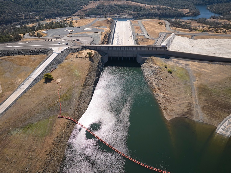
DWR Announces Initial State Water Project Allocations
The Department of Water Resources (DWR) announced on Dec. 1 an initial State Water Project (SWP) allocation forecast of 10 percent of requested supplies for 2024. The SWP provides water to 29 public water agencies that serve 27 million Californians.
The initial water supply forecast is the first allocation of the new water year, which began Oct. 1, and is based on current reservoir storage and an assumption of very dry conditions. So far in October and November, storms have not brought as much rain and snow. The allocation has no bearing on current water supplies or water captured in 2023. Most reservoirs in the state remain above average for this time of year following last water year’s wet winter.
More information on the initial SWP allocation announcement may be found in DWR’s press release.
Maintenance Work on Main Spillway Complete for the Season
DWR has completed routine maintenance work on Oroville Dam’s main spillway for the 2023 season.
Work this year included routine concrete repair, complete sealant replacement on concrete slabs and wall joints, and a complete inspection of the 51,000 feet of piping that supports the spillway’s improved drainage system.
Oroville Dam’s main spillway performed well and operated as designed in 2023, passing over 2,370,000 acre-feet of water – approximately 67 percent of the capacity of Lake Oroville. Due to seasonal temperature variations, spillway releases, and sun exposure, periodic concrete and joint sealant repairs of the main spillway are expected.
The spillway was rebuilt to the highest engineering and safety standards with oversight and guidance by the Federal Energy Regulatory Commission (FERC), Division of Safety of Dams (DSOD), and an independent board of consultants. DWR performed a significant amount of inspection and testing throughout construction to verify compliance with project specifications. DWR also provides regular updates to the Oroville Dam Citizens Advisory Commission, a public forum for discussing operations, maintenance, and public safety activities at Oroville Dam and its facilities.
Oroville Parade of Lights
Don’t miss Oroville’s annual Parade of Lights event this Saturday, Dec. 9, starting at 6 p.m. in downtown Oroville. This family-friendly event features a beautiful array of decorated floats with dancers, performers, and a marching band continuing the festive entertainment throughout the route. This year’s parade theme is “Christmas Throughout the Year: A Holiday Extravaganza” with floats representing each month of the year. Parade of Lights is organized by the Oroville Chamber of Commerce with event resource support provided by DWR. For more information about the Parade of Lights event, visit visitoroville.com.
Vegetation Management Activities
DWR and CAL FIRE’s Magalia Fire Center began vegetation cutting, piling, and burning activities this week near the Hyatt Powerplant along Oro Dam Blvd. East. Crews will be onsite Tuesday through Thursday each week, with vegetation management activities continuing for several months. In addition, fuel reduction activities are continuing in the Loafer Creek Recreation Area along Highway 162 (Oro Quincy Highway) for the next couple of weeks. Work schedules are subject to change depending on weather, crew, and equipment availability.
Work may cause intermittent trail closures within project areas. Recreational trail users should be cautious when entering work areas and obey all posted trail signage. Smoke from pile burning activities will be visible in the Oroville area.
DWR’s Fuel Load Management Plan works to reduce wildfire risk, increase public safety, and enhance forest health around the Lake Oroville area. Ongoing vegetation management of this critical area remains a high priority for DWR and its partners at CAL FIRE, Butte County Fire Department, Butte County Sheriff’s Office, California Conservation Corps (CCC), California Department of Parks and Recreation (State Parks), and the Butte County Fire Safe Council.
Salmon Surveys
DWR scientists are performing weekly surveys in the Feather River through Dec. 22 to record the number of Chinook salmon returning to spawn this season. Approximately two to three boats will be on the river during weekdays conducting surveys.
The weekday survey schedule is as follows, but is subject to change due to crew availability and the number of fish encountered:
- Monday: Robinson Riffle up to Highway 162
- Tuesday: Highway 70 to the top of the Auditorium Riffle
- Wednesday: Auditorium Riffle to the launch area by the Table Mountain Bridge
- Thursday: Thermalito Afterbay Outlet Boat Ramp upstream to Steep Riffle (near the Fish Monitoring Station); Thermalito Afterbay Outlet Boat Ramp downstream to the G-95 Riffle (near Mile Pond)
- Friday: Gridley Boat Ramp upstream through Hour Bars to the G-95 Riffle (near Mile Pond)
In future years, the fish survey will be phased out as DWR’s new Feather River Fish Monitoring Station will provide the data necessary to determine the number of Chinook salmon returning to spawn. While some select fish sampling will still occur in the low-flow channel, this will be at a much lower level than current surveying needs.
Oroville Recreation
The Lake Oroville Visitor Center will be temporarily closed Friday, Dec. 15 between 7 a.m. and noon for DWR staff training. Visitors may still access nearby trails and outside facilities during the temporary closure. Open seven days a week from 9 a.m. to 5 p.m., the Visitor Center features interpretive displays on Oroville Dam, area geology, wildlife and habitat, hydroelectric power, and cultural and historical artifacts. View videos in the theater about the construction of Oroville Dam, walk or hike along nearby trails, and visit the 47-foot-tall observation tower that provides unsurpassed panoramic views of surrounding areas. Free guided tours for school and community groups are available by reservation. Parking and admission to the Visitor Center are free.
DWR biologists are using the Feather River Fish Monitoring Station to determine abundance, run timing, and origin (hatchery or natural) of steelhead and Chinook salmon populations. This information will improve the management of these important fish populations. Upstream migrating fish totals between Sept. 11 and Dec. 2 are:
- Chinook salmon: 30,994
- Steelhead: 787
Feather River Fish Monitoring Station net totals are also manually updated weekly on CalFish.org.
DWR, State Parks, and the Department of Fish and Wildlife maintain over 92 miles of trails in the Oroville area. An interactive map of recreation facilities, including open trails and their permitted uses (hike, bike, horse, multi), is available on DWR’s Lake Oroville Recreation webpage. A paper trail map is available at various locations, including most entrance kiosks and the Lake Oroville Visitor Center. The marinas at Bidwell Canyon and Lime Saddle are open daily and provide a variety of services including a convenience store, gas, and boat rentals.
Current Lake Operations
Lake Oroville is at 812 feet elevation and storage is approximately 2.33 million acre-feet (MAF), which is 66 percent of its total capacity and 131 percent of the historical average.
Feather River flows remain at 650 cubic feet per second (cfs) through the City of Oroville with 1,100 cfs being released from the Thermalito Afterbay River Outlet (Outlet) for a total Feather River release of 1,750 cfs downstream. DWR continues to assess releases to the Feather River daily.
Visitors to Oroville Dam may also notice minor amounts of water flowing from drains built into the emergency spillway, which is normal and expected with the emergency spillway design. The dam and emergency spillway continue to operate as intended.
The public can track precipitation, snow, reservoir levels, and more at the California Data Exchange Center. The Lake Oroville gage station is identified as “ORO.”
All data as of midnight 12/7/2023.