Lake Oroville Community Update - December 15, 2023
Fuel load management work, including controlled burns, is conducted by CalFire in conjunction with California Department of Water Resources at Loafer Creek State Recreation Area in Oroville, California. The work is part of the fuel load management program which reduces fire risk, protects public safety, and enhances forest and watershed health. Photo taken March 2, 2022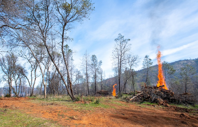
Salmon Spawning Operations
The Department of Water Resources (DWR) and the California Department of Fish and Wildlife (CDFW) completed spawning activities for spring, inland, and fall-run Chinook salmon at the Feather River Fish Hatchery in Oroville. The Hatchery collected enough eggs to meet its production goals and anticipates meeting target release numbers of 2 million spring-run, 125,000 inland Chinook destined for Lake Oroville, and 6 million fall-run, with an additional 3.5 million fall-run to be released to mitigate declines in Chinook salmon populations during recent drought years. Chinook salmon fingerlings raised at the Hatchery will later be released in the Feather River and San Francisco Bays to support inland and ocean fisheries. In addition, DWR and CDFW continued thiamine treatment to combat B1 vitamin deficiencies. This treatment improves the health of the fish, increasing the survival of Chinook salmon from egg to juvenile.
Thanks to a recently completed spawning gravel improvement project in the Feather River, combined with the substantial number of salmon that returned to the Feather River this fall, high levels of in-river spawning have been seen over the last few months. DWR’s newly installed Feather River Fish Monitoring Station counted upstream migrating fish totals of 31,003 Chinook salmon and 787 steelhead between Sept. 11 and Dec. 6. The monitoring totals help improve management of these important fish populations in the Feather River and at the Feather River Fish Hatchery.
Vegetation Management Activities
DWR and CAL FIRE’s Magalia Fire Center began vegetation cutting, piling, and burning activities last week near the Hyatt Powerplant along Oro Dam Blvd. East. Crews will be onsite Tuesday through Thursday each week, with vegetation management activities continuing for several months. In addition, fuel reduction activities are continuing in the Loafer Creek Recreation Area along Highway 162 (Oro Quincy Highway) with work also beginning soon in the Bidwell Canyon and Kelly Ridge areas. Work schedules are subject to change depending on weather, crew, and equipment availability.
Work may cause intermittent trail closures within project areas. Recreational trail users should be cautious when entering work areas and obey all posted trail signage. Smoke from pile burning activities will be visible in the Oroville area.
DWR’s Fuel Load Management Plan works to reduce wildfire risk, increase public safety, and enhance forest health around the Lake Oroville area. Ongoing vegetation management of this critical area remains a high priority for DWR and its partners at CAL FIRE, Butte County Fire Department, Butte County Sheriff’s Office, California Conservation Corps (CCC), California Department of Parks and Recreation (State Parks), and the Butte County Fire Safe Council.
Maintenance Work on Main Spillway Complete for the Season
DWR has completed routine maintenance work on Oroville Dam’s main spillway for the 2023 season. Work this year included routine concrete repair, complete sealant replacement on concrete slabs and wall joints, and a complete inspection of the 51,000 feet of piping that supports the spillway’s improved drainage system.
Oroville Dam’s main spillway performed well and operated as designed in 2023, passing over 2,370,000 acre-feet of water – approximately 67 percent of the capacity of Lake Oroville. Due to seasonal temperature variations, spillway releases, and sun exposure, periodic concrete and joint sealant repairs of the main spillway are expected.
The spillway was rebuilt to the highest engineering and safety standards with oversight and guidance by the Federal Energy Regulatory Commission (FERC), Division of Safety of Dams (DSOD), and an independent board of consultants. DWR performed a significant amount of inspection and testing throughout construction to verify compliance with project specifications. DWR also provides regular updates to the Oroville Dam Citizens Advisory Commission, a public forum for discussing operations, maintenance, and public safety activities at Oroville Dam and its facilities.
Salmon Surveys
DWR scientists are performing weekly surveys in the Feather River through Dec. 22 to record the number of Chinook salmon returning to spawn this season. Approximately two to three boats will be on the river during weekdays conducting surveys.
The weekday survey schedule is as follows, but is subject to change due to crew availability and the number of fish encountered:
- Monday: Robinson Riffle up to Highway 162
- Tuesday: Highway 70 to the top of the Auditorium Riffle
- Wednesday: Auditorium Riffle to the launch area by the Table Mountain Bridge
- Thursday: Thermalito Afterbay Outlet Boat Ramp upstream to Steep Riffle (near the Fish Monitoring Station); Thermalito Afterbay Outlet Boat Ramp downstream to the G-95 Riffle (near Mile Pond)
- Friday: Gridley Boat Ramp upstream through Hour Bars to the G-95 Riffle (near Mile Pond)
In future years, the fish survey will be phased out as DWR’s new Feather River Fish Monitoring Station will provide the data necessary to determine the number of Chinook salmon returning to spawn. While some select fish sampling will still occur in the low-flow channel, this will be at a much lower level than current surveying needs.
Oroville Recreation
DWR, State Parks, and CDFW maintain over 92 miles of trails in the Oroville area. An interactive map of recreation facilities, including open trails and their permitted uses (hike, bike, horse, multi), is available on DWR’s Lake Oroville Recreation webpage. A paper trail map is available at various locations, including most entrance kiosks and the Lake Oroville Visitor Center. The marinas at Bidwell Canyon and Lime Saddle are open daily and provide a variety of services including a convenience store, gas, and boat rentals.
The Lake Oroville Visitor Center is open seven days a week from 9 a.m. to 5 p.m. Staffed by knowledgeable guides, the Visitor Center features interpretive displays on Oroville Dam, area geology, wildlife and habitat, hydroelectric power, and cultural and historical artifacts. View videos in the theater about the construction of Oroville Dam, walk or hike along nearby trails, and visit the 47-foot-tall observation tower that provides unsurpassed panoramic views of surrounding areas. Free guided tours for school and community groups are available by reservation. Parking and admission to the Visitor Center are free.
Current Lake Operations
Lake Oroville is at 812 feet elevation and storage is approximately 2.32 million acre-feet (MAF), which is 66 percent of its total capacity and 129 percent of the historical average.
Feather River flows remain at 650 cubic feet per second (cfs) through the City of Oroville with 1,100 cfs being released from the Thermalito Afterbay River Outlet (Outlet) for a total Feather River release of 1,750 cfs downstream. DWR continues to assess releases to the Feather River daily.
Visitors to Oroville Dam may also notice minor amounts of water flowing from drains built into the emergency spillway, which is normal and expected with the emergency spillway design. The dam and emergency spillway continue to operate as intended.
The public can track precipitation, snow, reservoir levels, and more at the California Data Exchange Center. The Lake Oroville gage station is identified as “ORO.”
All data as of midnight 12/14/2023.
###
Know someone who would like to receive Community Updates? They can email their request to oroville@water.ca.gov.