Lake Oroville Community Update - October 28, 2022
Visibly low water conditions shown in this aerial photograph taken via drone at Lake Oroville in Butte County.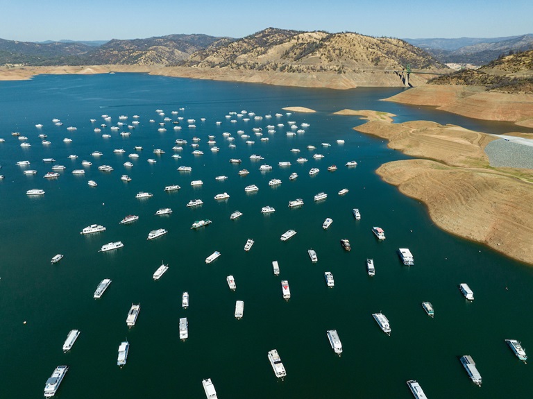
Control Burn at Loafer Creek
CAL FIRE, Butte County Fire Department, Plumas National Forest, and partners Department of Water Resources (DWR) and California Department of Parks and Recreation (State Parks) will be continuing their planned control burn on over 200 acres in the Loafer Creek Recreation Area near Lake Oroville. The goal of the control burn is to remove overgrown ladder fuels and dead and dying vegetation and minimize ground fuels to create a more wildfire resistant landscape.
Around 116 acres have been treated as of Thursday night and over 95 acres are being targeted in the southwest portion of Loafer Creek. Multiple burn areas are planned beginning Monday, Oct. 31 and through the week, causing some intermittent trail closures in the Loafer Creek Recreation Area. Trail users are advised to be “safety-aware” and obey posted trail closure signage.
Control burn activities will take place depending on weather and incident activity in Butte County. Smoke from the activity has been, and may continue to be, visible in the Oroville area.
DWR’s Fuel Load Management Plan (FLMP) works to reduce wildfire risk and increase public safety around Lake Oroville. Previous FLMP projects in the Loafer Creek Recreation Area have been identified as contributing to the slowing of the 2020 North Complex Fire as it approached Kelly Ridge, increasing firefighters’ ability to establish a secure fire line, and preventing the fire from progressing. Ongoing management of this critical area remains a high priority for the FLMP.
Oroville Radial Gates Project
DWR and contractor staff successfully reinstalled the gate hoist assembly on Gate #8 at Oroville Dam’s Flood Control Outlet (FCO), or main spillway which will be available and fully operational throughout the flood season. The work was part of a multi-year project to perform maintenance repairs on the eight radial gate hoist assemblies of the FCO as part of the Oroville Radial Gates Maintenance Repair Project.
Unico will now begin work on the design and fabrication of a replica hoist that will be installed while subsequent hoists are removed for inspection and full maintenance repairs to address any deficiencies due to wear, age, and serviceability of the equipment. The design and fabrication phase of the project is anticipated to be completed by May 2023.
Occurring yearly beginning in 2023, maintenance repairs will be performed on one gate hoist assembly per year during the dry season (May 1 to Oct. 31) using the spare hoist assembly. The project is anticipated to be fully completed for all eight radial gates in 2030.
Flood Preparedness Week
More than seven million California residents are at risk of flooding, and many don’t realize it. Flooding happens throughout the state; every California county has received a flood-related emergency declaration in the past 20 years and flood events during and after drought conditions are not uncommon.
Make sure you are prepared for flood events through these three steps:
- Be aware of your risk: Know whether your home is in a flood zone; pay attention to weather forecasts; and listen to local authorities.
- Be prepared: Always have an emergency evacuation kit ready; be prepared to evacuate early; have a household inventory with copies of critical documents; and have a plan for where you will go in an emergency and what to do with your pets.
- Take action: Evacuate immediately when advised to. Also, homeowners’ insurance does not cover damage due to flooding; consider purchasing flood insurance.
Even in drought conditions, climate change is resulting in extreme variations of weather, including large storm events which increase risk of flooding, particularly in areas damaged by wildfire. Wildfires dramatically change the landscape and ground conditions in a watershed. Natural, unburned vegetation and soil normally act as a sponge during a rainfall event. However, the heat from a fire can bake the ground, creating a surface that will not absorb water and can increase the speed with which water flows off the slope, leading to damaging, and sometimes catastrophic, mud and debris flows. These conditions can be present for years after a wildfire. Visit DWR’s Flood Preparedness webpage for information about keeping you, your loved ones, and community safe.
Oroville Dam Citizens Advisory Commission
The California Natural Resources Agency hosted the 12th Oroville Dam Citizens Advisory Commission meeting Oct. 21 at Southside Community Center in Oroville. In addition to public comment, presentations on inundation maps and new atmospheric river research, and an update on Oroville Dam facility winter operations, the Commission also announced it is collecting comments on the draft 3-year report of the Commission’s activities. Visit the Commission’s report webpage at https://resources.ca.gov/Initiatives/Oroville-Dam-Citizens-Advisory-Commission/Oroville-Dam-Citizens-Advisory-Commission-Report for details.
The Citizens Advisory Commission is a forum for questions and feedback from the communities surrounding Oroville Dam. For information on the meeting, please visit https://bit.ly/OrovilleCAC. A transcript of the meeting will be available on this webpage in the coming weeks.
Oroville Recreation
The Loafer Point Stage II boat ramp is expected to close the week of Oct. 31 due to falling lake levels. The Bidwell Canyon Stage III boat ramp remains open for boating and for fishing enthusiasts who are finding success at Lake Oroville.
The Feather River Fish Hatchery continues to perform spawning, rearing, and stocking activities and is open daily 8 a.m. to 3 p.m. The Fish Barrier Dam Overlook area and underwater viewing window is open sunrise to sunset.
DWR and State Parks maintain over 92 miles of trails in the Oroville area, including around the Lake Oroville Visitor Center. Paved trails there and at the North Forebay Day Use Area offer accessible trails with only slight elevation changes. Other trails, such as the Brad Freeman Trail between the Spillway Day Use Area and the Diversion Pool, offer trails with steep elevation changes to challenge hikers and mountain bikers. The Saddle Dam Trailhead has facilities for equestrians, including a large parking area to accommodate horse trailers, water trough, and hitching posts, and easy access to trails designated for hikers and horses.
Trails and their permitted uses (hike, bike, horse, multi), day use areas, boat ramps, and other recreation facilities are featured on DWR’s interactive map on DWR’s Lake Oroville Recreation webpage at https://water.ca.gov/What-We-Do/Recreation/Lake-Oroville-Recreation.
Current Lake Operations
The elevation of Oroville’s reservoir is about 682 feet elevation and storage is about 1.12 million acre-feet (MAF), which is 32 percent of its total capacity and 62 percent of historical average. Warmer temperatures are forecast for the weekend, cooling down next week with temperatures dropping into the low-to-upper-60s.
The Feather River releases are currently at 2,400 cubic feet per second (cfs) and continue to meet downstream Delta water quality and outflow needs. Flows through the City of Oroville are 650 cfs with 1,750 cfs released from the Thermalito Afterbay Outlet (Outlet) for a total of 2,400 cfs downstream of the Outlet. DWR continues to assess releases to the Feather River daily.
The public can track precipitation, snow, reservoir levels, and more at the California Data Exchange Center at www.cdec.water.ca.gov. The Lake Oroville gage station is identified as “ORO”.
All data as of midnight 10/27/2022
California is in a third year of drought. With water conservation now a way of life in California, everyone is encouraged to find ways to save water. See tips, tools, and ideas on the Save Our Water website. Information about real time local hydrological conditions, forecasts, and water conditions is available on DWR’s new website California Water Watch. Visit DWR’s Drought webpage for the latest information.