Lake Oroville Community Update - April 1, 2022
Aerial drone footage of Lake Oroville on March 17, 2022.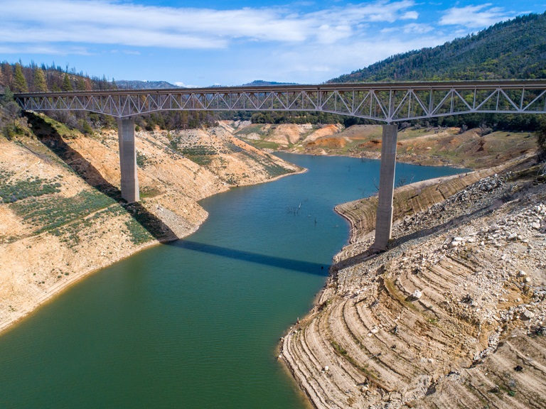
Snowpack Survey
The Department of Water Resources (DWR) conducted the fourth snow survey of the season Friday at Phillips Station near Echo Summit. Following a January, February, and March that will enter records as the driest documented in state history, the manual survey recorded 2.5 inches of snow depth and a snow water equivalent of 1 inch, which is 4 percent of average for this location for April.
The snow water equivalent measures the amount of water contained in the snowpack and is a key component of DWR’s water supply forecast. Statewide, the snowpack is 38 percent of average for this date.
“The conditions we are seeing today speak to how severe our drought remains. DWR has been planning for the reality of a third dry year since the start of the water year on October 1,” said DWR Director Karla Nemeth. “While DWR has made significant investments in forecasting technology and other tools to ensure we make the most out of the snowmelt we do receive, water conservation will remain our best tool in the face of this ongoing drought and the statewide impacts of a warming climate. All Californians must focus on conserving water now.” The full snow survey news release can be found on the DWR News page.
Governor Gavin Newsom has asked all Californians to cut back water use at least 15 percent compared to 2020 levels. Current water conditions are now available in real time at California Water Watch, a new website launched by DWR. The website will help Californians see their local hydrological conditions, forecasts, and water conditions down to their address or their local watershed. Additional tips on how to conserve can be found at the SaveOurWater webpage.
Boat Ramp Closures
A speed boat timed trial event on the Thermalito Afterbay is scheduled for April 1 to April 3. The event requires the southern portion of the Afterbay (south of Highway 162) to be closed to the public April 2 and April 3. Both the Monument Hill boat ramp and Larkin Cartop boat launch will be closed. The Wilbur Road boat ramp and areas north of Hwy 162 will remain open.
Returning to the Afterbay after two years away due to the COVID-19 pandemic, the 59th Annual Region 9 Bud David Time Trials event is anticipated to draw 40 to 50 boats. Information about the event can be found on the American Power Boat Association webpage at https://www.apba.org/racing-schedule.html
The Loafer Point boat launch area will be closed Monday, April 4 for installation of a gate. Boaters are encouraged to use the Bidwell Canyon boat ramp as an alternate launch site on that day.
Oroville Dam Citizens Advisory Commission
The California Natural Resources Agency (CNRA) held its tenth Oroville Dam Citizens Advisory Commission meeting on March 25, 2022. The online public meeting included a facilities update from the Department of Water Resources (DWR), a presentation on addressing flood risks, and a discussion about public safety partnerships. Members of the public also offered comments and asked questions. The Citizens Advisory Commission is a forum to provide public feedback from the communities surrounding Oroville Dam. The meeting transcript and presentations will be available on the Commission’s website in the coming weeks at https://bit.ly/OrovilleCAC.
Oroville Recreation
The Loafer Point, Bidwell Canyon, and Lime Saddle boat ramps are open (except on April 4 for Loafer Point). The Oroville Dam Spillway boat ramp remains closed for repairs. The Foreman Creek and Stringtown cartop boat ramps are also open. Information on current boat ramp status can be found on the California State Parks’ Lake Oroville State Recreation Area webpage. Scroll down to the link for “Current Launch Ramp Status”.
The Loafer Creek Recreation Area is now open for all activities except group camping.
The Lake Oroville Visitor Center is open to the public on Tuesdays, Wednesdays, and Thursdays from 9 a.m. to 5 p.m. Pick up the Lake Oroville Trails Map, which shows more than 91 miles of trails available to equestrians, bicyclists, and hikers, at Lake Oroville State Recreation Area (LOSRA) kiosks, the Oroville Area Chamber of Commerce, or the Feather River Recreation and Parks District.
Visit the California Parks LOSRA webpage for current information on facility status and campground reservations. An interactive map of recreation facilities in DWR’s Oroville-Thermalito Complex is available on DWR’s Lake Oroville Recreation webpage. Information about the 11,000-acre Oroville Wildlife Area is available on the California Department of Fish and Wildlife webpage.
Current Lake Operations
The elevation of Oroville’s reservoir is about 749 feet elevation and storage is about 1.68 million acre-feet, which is 47 percent of its total capacity and 67 percent of historical average. Dry conditions and temperatures in the 80s are forecasted this weekend and next week.
The average daily inflows this week have been around 5,000 cubic feet per second (cfs). These higher inflows are attributed to early season snowmelt and projected in the 3,000 to 4,000 cfs range next week. Inflows are subject to change based upon actual weather conditions.
Total flows to the Feather River are 3,500 cfs. Flow in the low-flow channel through the City of Oroville is 650 cfs and flow through the Thermalito Afterbay Outlet currently is 2,850 cfs. DWR is planning a reduction of releases to the Feather River in early April.
The public can track precipitation, snow, reservoir levels, and more at the California Data Exchange Center at www.cdec.water.ca.gov. The Lake Oroville gage station is identified as “ORO”.
All data as of midnight 3/31/2022