Lake Oroville Community Update - April 22, 2022
Goats grazing to assist in reducing overgrown vegetation.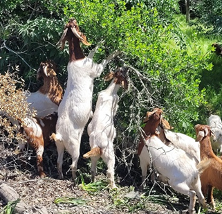
DWR Partners with California Rice Commission
The Department of Water Resources (DWR) has provided $8 million dollars to the California Rice Commission’s ‘California Ricelands Waterbird Foundation’ to help increase the amount of available flooded habitat for migratory birds making their journey along the Pacific Flyway this year. Current drought conditions have reduced summer flooding of semi-permanent wetlands in the Sacramento Valley, reducing essential resources for breeding waterfowl, shorebirds, and other wetland-dependent species that are severely impacted by the drought.
This past winter and through the spring, DWR supported a collaboration of multiple partners, including Audubon California, Ducks Unlimited, The Nature Conservancy, California Department of Fish and Wildlife (CDFW) and others, to create nearly 55,000 acres of flooded waterbird habitat on rice fields and private wetlands by providing incentive payments to wetland owners to flood (or hold water from winter flooding) their wetlands to a depth of 12 to 24 inches beginning April 1, 2022 until July 15, 2022. After July 15, wetland managers will rely on evaporation (vs. draining) to draw down flooded fields, extending vital habitat for migrating shorebirds who prefer shallow waters.
As the DWR manages California’s water needs during this water supply crisis, actions and projects like this one to minimize the impacts of drought and water management on our environment (while still meeting the needs of our communities’ health and safety, our economy, and agriculture), will significantly benefit wildfowl migrating up and down the Western United States as well as those who live in the Valley year-round.
Flood Safety Stakeholder Technical Workshop
The Oroville Dam Citizens Advisory Commission held a virtual Flood Safety Stakeholder Technical Workshop on April 22 to allow the California Natural Resources Agency (CNRA), DWR, and other government officials hear directly from and speak directly to community stakeholders about their goals, interests and concerns related to flood safety and downstream communities. Presentations on extreme precipitation, managing floods, forecasting, and how dams, channels, floodplains, burn scars, and adequate preparations impact flooding and response were provided. Stakeholders and public participants asked questions and offered comments. The meeting transcript and presentations will be available on the Commission’s website in the coming weeks at https://bit.ly/OrovilleCAC.
Grazing Goats Reduce Fire Risk
Hillsides along the Dan Beebe trail near Hyatt Powerplant and Oroville Dam’s Lower Overlook are looking different as 600 goats and sheep from the Hanski Family Farms are visiting the area. The goal for this grazing effort is to minimize the rate of spread of a potential fire by reducing ground fuels, ladder fuels, and overgrown vegetation on approximately 35 acres near Oro Dam Boulevard East.
Grazing is gaining popularity across California as a sustainable method to minimize wildfire risk and lessen the spread of a wildfire through vegetation management. The goats and sheep near Hyatt Powerplant will graze on grasses, leaves, poison oak, and a variety of shrubs and trees. By standing on their hind legs, they can reduce ladder fuels up to six feet high. Plus, they love to eat weeds, especially invasive ones.
The goat grazing project is part of DWR’s Fuel Load Management Plan, which helps reduce wildfire risk, increase public safety, and enhance forest health in areas around Lake Oroville within the Federal Energy Regulatory Commission (FERC) project boundary. In partnership with Butte County Fire Safe Council, DWR continues to use grazing as a sustainable method of fuel reduction around DWR’s Oroville-Thermalito Complex.
To learn more and to see goat grazing in action, visit DWRs YouTube Channel for a video of the March 2021 Lakeland Boulevard goat grazing project on DWR’s YouTube webpage.
Oroville Recreation
The Loafer Point, Bidwell Canyon, and Lime Saddle boat ramps are open. The Oroville Dam Spillway boat ramp remains closed for repairs. The Foreman Creek and Stringtown cartop boat ramps are also open. Information on current boat ramp status can be found on the California State Parks’ Lake Oroville State Recreation Area webpage. Scroll down to the link for “Current Launch Ramp Status”.
The Loafer Creek Recreation Area is now open for all activities except group camping.
The Lake Oroville Visitor Center is open to the public on Tuesdays, Wednesdays, and Thursdays from 9 a.m. to 5 p.m. Pick up the Lake Oroville Trails Map, which shows more than 91 miles of trails available to equestrians, bicyclists, and hikers, at Lake Oroville State Recreation Area (LOSRA) kiosks, the Oroville Area Chamber of Commerce, or the Feather River Recreation and Parks District.
Visit the California Parks LOSRA webpage for current information on facility status and campground reservations. An interactive map of recreation facilities in DWR’s Oroville-Thermalito Complex is available on DWR’s Lake Oroville Recreation webpage. Information about the 11,000-acre Oroville Wildlife Area is available on the California Department of Fish and Wildlife webpage.
Current Lake Operations
The elevation of Oroville’s reservoir is about 764 feet elevation and storage is about 1.81 million acre-feet, which is 51 percent of its total capacity and 68 percent of historical average. Dry and warmer conditions are forecasted this weekend and into the week with temperatures in the mid-70s to low-80s.
Because of the recent rain, average daily inflows this week have been between 6,000 to 10,000 cubic feet per second (cfs) and are projected to remain in this range through the weekend and into next week. Flows to the Feather River are 800 cfs. Flow in the low-flow channel through the City of Oroville is 650 cfs and flow through the Thermalito Afterbay Outlet currently is 150 cfs. Flows are assessed daily.
The public can track precipitation, snow, reservoir levels, and more at the California Data Exchange Center at www.cdec.water.ca.gov. The Lake Oroville gage station is identified as “ORO”.
All data as of midnight 4/21/2022