Lake Oroville Community Update - October 22, 2021
The Bidwell Bar Bridge and houseboats near the Bidwell Canyon Marina on Lake Oroville on September 28, 2021.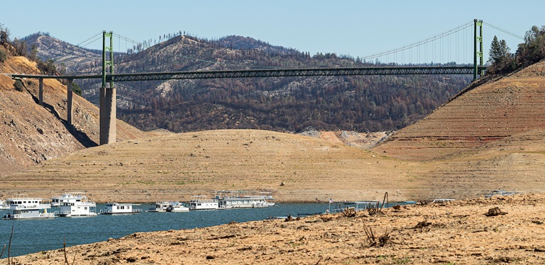
Flood Preparedness Week
More than seven million California residents are at risk of flooding, and many don’t realize it. Flooding happens throughout the state; every California county has received a flood-related emergency declaration in the past 20 years and flood events during and after drought conditions are not uncommon.
Make sure you are prepared for flood events through these three steps:
- Be aware of your risk: Know whether your home is in a flood zone; pay attention to weather forecasts; and listen to local authorities.
- Be prepared: Always have an emergency evacuation kit ready; be prepared to evacuate early; have a household inventory with copies of critical documents; and have a plan for where you will go in an emergency and what to do with your pets.
- Take action: Evacuate immediately when advised to. Also, homeowners’ insurance does not cover damage due to flooding; consider purchasing flood insurance.
This year, many communities are at additional risk for flooding because of wildfire damage as evidenced by this week’s National Weather Service’s Flash Flood Watch for the North Complex and Dixie wildfire burn scar areas. Wildfires dramatically change the landscape and ground conditions in a watershed. Natural, unburned vegetation and soil normally act as a sponge during a rainfall event. However, the heat from a fire can bake the ground, creating a surface that will not absorb water and can increase the speed with which water flows off the slope, leading to damaging, and sometimes catastrophic, mud and debris flows. These conditions can be present for years after a wildfire. Visit DWR’s Flood Preparedness webpage for information about keeping you, your loved ones, and community safe.
Water Quality Working Group
In late fall of 2020, Butte County, the Governor’s Office of Emergency Services (CalOES), Department of Water Resources (DWR), State Water Resources Control Board and Regional Water Quality Control Boards (Water Boards), California Department of Fish and Wildlife, California Department of Parks and Recreation, and local water purveyors formed the North Complex Watershed Working Group to monitor and evaluate watershed and infrastructure response to the North Complex wildfire from 2020.
This working group has expanded its scope to include impacts from the 2021 Dixie Fire and will now be called the Feather River Watershed Working Group (Working Group). Additional partner agencies, including affected counties such as Plumas County, have joined others from local, state, and federal levels to coordinate regarding water quality and infrastructure impacts in the watershed. Members of the Working Group also provide technical guidance and expertise to local agencies and partners on water quality monitoring and protections in the post-fire environment.
The Working Group is preparing for the upcoming rainy season and currently meets bi-weekly, with the option to increase meeting frequency as the season progresses. The Working Group will continue to provide the public with informational updates on watershed conditions and water quality testing results as they become available. The summary of last year’s findings can be found on the Water Boards’ July 8, 2021 news release.
Lake Oroville Boating
The temporary, single-lane boat ramp at Oroville Dam’s Spillway Boat Ramp area has reopened for public use from 6 a.m. to 8 p.m. to launch trailered boats. Vehicles within the parking lot at closing time will be locked in until the next morning.
Lake levels are expected to substantially increase as a result of weekend storms. Boaters are advised to park vehicles and trailers well above lake level when boating on the lake.
The spillway auxiliary ramp has a gravel surface which becomes slippery when wet, especially during times of heavy usage. To maintain the integrity of the ramp, drivers must avoid tire spin by placing vehicles in 4-wheel drive and accelerating slowly when exiting the ramp, with or without a loaded trailer. As weather conditions and lake levels change, the fitness of the ramp for continued use will be regularly assessed.
Boaters on the lake are advised to be aware of unexpected shallow water and obstruction hazards such as partially submerged trees now that lake levels have reached historic lows. State Parks has issued an order for the Lake Oroville State Recreation Area (LOSRA) that boating access on Lake Oroville is not permitted starting one-half hour after sunset and ending one-half hour before sunrise due to navigational hazards. Houseboats and vessels remaining on the water must be on their mooring ball or in a slip during hours of lake closure. Additional information can be obtained by calling State Parks at (530) 538-2200.
All access to boats and houseboats at both Bidwell Canyon and Lime Saddle Marinas must be coordinated through the marina prior to arrival by calling 530-589-9175 or by utilizing the shuttle service at Bidwell Canyon Marina. Shuttle services to Lime Saddle Marina is not being provided at this time. The Thermalito Afterbay and Thermalito South Forebay continue to be open to power boating.
CAL FIRE Work at Loafer Creek
Beginning Friday Oct.22, the Butte County burn suspension will be lifted and residential and fire hazard reduction burning will be allowed on permissive burn days. Crews from the Butte Fire Center and CAL FIRE are taking advantage of wet weather to start burning the piles of brush, burnt vegetation, and hazard trees that was removed last season in the North Complex wildfire burn scar. Smoke from the burn piles may be visible from the Oro Quincy Highway (Highway 162). The CAL FIRE news release is available here.
Through DWR’s Fuel Load Management Program, DWR partners with CAL FIRE, the California Conservation Corps, Butte County Sheriff Office, Butte County Fire Safe Council, and others on vegetation management projects to reduce fire risk, increase public safety, protect infrastructure, and enhance forest health in areas around Lake Oroville. Approximately 840 acres have been manually thinned, re-thinned, grazed, and/or treated with prescribed fire since November 2012. DWR’s goal is to treat 150 acres this season.
Oroville Recreation
Numerous Day Use Area (DUA) facilities with picnic tables and restrooms at Lake Oroville State Recreation Area (LOSRA) are open 8 a.m. to sunset. Bidwell, Lime Saddle, and Loafer Creek recreation areas are open 24 hours. The Oroville Dam Crest Road across Oroville Dam is available 5 a.m. to 11 p.m. daily with the Spillway trailhead and boat launch open from 6 a.m. to 8 p.m.
The top of the dam is open to pedestrians and bicyclists 24-hours a day. The Lake Oroville Visitor Center anticipates re-opening later this year.
Over 97 miles of trails around Lake Oroville, along the Feather River, Thermalito Diversion Pool, Forebays and Afterbay, and the Oroville Wildlife Area are available to equestrians, bicyclists, and hikers wishing to explore Oroville’s natural beauty in the cooler fall weather. Trail maps are available at many Oroville locations including Lake Oroville State Recreation Area (LOSRA) kiosks, Oroville Wildlife Area office on Oro Dam Boulevard West, the Oroville Area Chamber of Commerce, and Feather River Recreation and Parks District.
The Forebay Aquatic Center at the North Forebay recreation area has closed for the season but the recreation area remains open with picnic tables, restrooms, and beach facilities. Visit the California Parks LOSRA webpage for current information on facility status and campground reservations. An interactive map of recreation facilities in DWR’s Oroville-Thermalito Complex is available on DWR’s Lake Oroville Recreation webpage. Information about the 11,000-acre Oroville Wildlife Area is available on the California Department of Fish and Wildlife webpage.
Chinook Salmon Spawning in the Feather River
Chinook salmon are completing their life cycle and returning home to the Feather River to lay eggs for the next generation of salmon. The Feather River Fish Hatchery’s fish ladder is open and hatchery spawning operations – which enable millions of Chinook salmon to be released to the river every spring – are underway.
To protect public health during the COVID-19 pandemic, the hatchery continues to be closed. Visitors can still enjoy seeing salmon climb the fish ladder at the Underwater Viewing Area and Overlook near the Feather River’s Fish Diversion Dam north of the hatchery. The public is urged to maintain physical distancing and abide by Butte County requirements for mask-wearing to protect personal health and the health of others.
Loafer Point Stage II Boat Ramp Extension
Construction work to extend three lanes of the Loafer Point Stage II boat ramp farther into the dry lakebed of Lake Oroville continues. Earthwork and ramp construction will continue until winter precipitation causes lake levels to rise. The existing Stage II facility was completed this spring, providing six new boat launch lanes extending to elevation 702 feet and 180 trailered parking spaces. The new launch lanes are anticipated to go as low as 640 feet elevation.
Visitors and nearby residents are reminded to be aware of construction equipment and vehicles, including those entering and exiting the Loafer Creek recreation area at Oro-Quincy Highway.
Current Lake Operations
The elevation of Oroville’s reservoir is about 629 feet elevation and storage is about 792,000-acre-feet, which is 22 percent of its total capacity and 37 percent of historical average. Water year 2022 is starting off with a series of atmospheric river storms making landfall in northern California over the next six days. The Feather River watershed is forecasted to see up to 10 inches of rain during that time.
Although the storms will not be enough to end the drought conditions, they will provide much needed rainfall to the very dry Feather River watershed. Saturated soils in the watershed will result in higher runoff into streams, rivers, and reservoirs and is anticipated to result in an approximately 20-feet increase in Lake Oroville’s lake elevation. Visitors are advised to park well above lake level when visiting or boating on the lake.
Total flows to the Feather River are 1,250 cubic feet per second (cfs) for meeting downstream water quality and flow requirements. Flow in the low-flow channel, through the City of Oroville, is 650 cfs and flow through the Thermalito Afterbay Outlet is 600 cfs. Total releases to the Feather River are assessed daily.
The public can track precipitation, snow, reservoir levels, and more at the California Data Exchange Center at www.cdec.water.ca.gov. Lake Oroville is identified as “ORO”.
All data as of midnight 10/21/2021