Lake Oroville Community Update - November 5, 2021
Lake Oroville at Oroville Dam Boat Launch at an elevation of 659.98 feet, 28 percent of total capacity on October 29, 2021.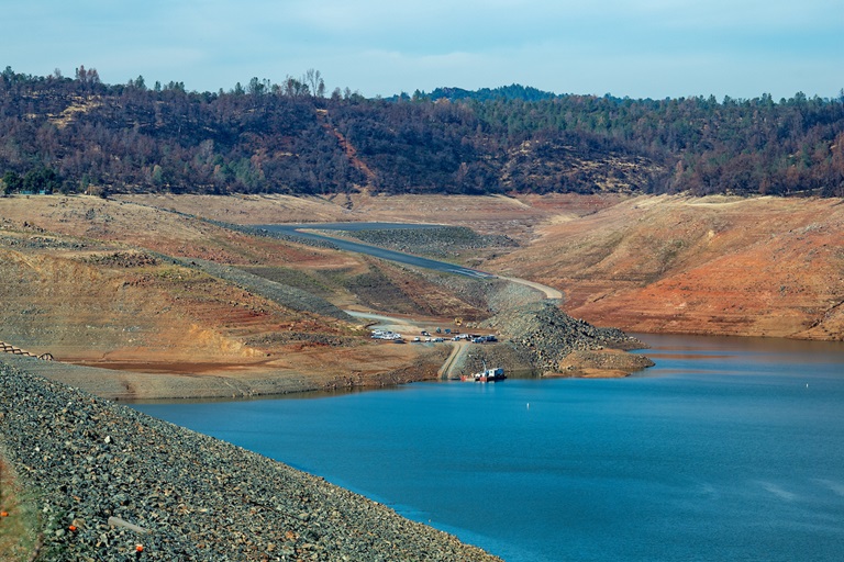
Lake Oroville Visitor Center
The Lake Oroville Visitor Center is now open to the public on Tuesdays, Wednesdays, and Thursdays from 9 a.m. to 5 p.m. Visitors can tour the Center’s exhibits on the construction of Oroville Dam – the tallest dam in the country; the State Water Project which provides water to 27 million Californians and 750,000 acres of farmland; a new interactive water education exhibit, and much more.
The visitor center also has a theater featuring videos on local topics and places such as Oroville Dam and the Feather River Fish Hatchery as well as walking and hiking trails showcasing local flora and fauna. A highlight of the visitor center is the 47-foot-high observation tower providing unsurpassed panoramic views of the lake, valley, foothills, Sierra Nevada range and the Sutter Buttes - the smallest mountain range in the world.
Visitor center guides are available to provide tours of the facility to groups and classrooms. Previously provided tours of the Feather River Fish Hatchery are not available while the main hatchery is closed to the public. The nearby Fish Barrier Dam overlook, fish ladder, and underwater viewing window - all with interpretive signage - remain open to the public. Please contact the VC Guides at 530-538-2219 for more information.
Oroville Recreation Advisory Committee
The Oroville Recreation Advisory Committee held a public virtual meeting on Friday, Nov. 5. ORAC was established by the Federal Energy Regulatory Commission (FERC) to review and provide recommendations regarding the Department of Water Resources’ (DWR) recreation plan for the Project No. 2100 – Oroville Facilities. The 13-member committee is made up of representatives from state and local government, sports and recreation groups, and business and community organizations. To obtain a summary of the meeting, send a request to oroville@water.ca.gov.
Loafer Creek Fuels Management
CAL FIRE/Butte County Fire Department ignited burn piles in the Loafer Creek Recreation Area this week to remove dangerous fuels collected in the North Complex wildfire (2020) burn scar area. The piles will be closely monitored and smoke may be visible at times in the Kelly Ridge and Greater Oroville areas throughout the duration of the project.
DWR, CAL FIRE, and California Department of Parks and Recreation (State Parks) partner on DWR’s Fuel Load Management Plan and CAL FIRE’s Vegetation Management Plan to reduce wildfire risk and increase public safety around the FERC project boundary, including Lake Oroville.
Over the next several weeks, crews from California Conservation Corps, Butte County Sheriff Office, and CAL FIRE’s Butte Fire Center will be performing various fuel reduction projects using heavy equipment, hand cutting, chipping, and burning of prioritized overgrown vegetative areas within the FERC project boundary. Trail users and visitors to the area and motorists along Highway 162 are advised to be mindful of safety when near work zones.
With help from area partners, approximately 840 acres have been manually thinned, re-thinned, grazed, and/or treated with prescribed fire since November 2012. DWR’s goal is to treat 150 acres this season.
Lakeside Access Road Construction
The Lakeside Access Road project began this week. This project will consist of a new, permanent, paved road from the west side of Oroville Dam to the Spillway Boat Ramp parking lot on the “lakeside,” or waterside, of the Oroville Dam spillways. This new road will allow a more direct route when water levels are low in Lake Oroville. The new road will include two concrete traffic lanes, wide shoulders for walking and biking, guardrails, and safety signage. Additionally, the contractor will be removing and replacing deteriorating asphalt from the Stage I Spillway Boat Ramp.
Visitors to Oroville Dam can expect to see large construction equipment and material deliveries in the area through January as the contractor works to complete the project. Please use caution and respect the construction fencing and safety signage when visiting Oroville Dam or the Spillway Boat Ramp.
Lake Oroville Boating
The temporary, single-lane boat ramp at Oroville Dam’s Spillway Boat Ramp area is open for public use from 6 a.m. to 8 p.m. to launch trailered boats. Vehicles within the parking lot at closing time will be locked in until the next morning. The water depth covering the bottom of Bidwell Canyon paved Stage III boat ramp is still not deep enough to provide safe boat launching.
Lake levels have and are expected to continue to increase as a result because of recent and forecasted rainfall events. Boaters are advised to park vehicles and trailers well above lake level when boating on the lake.
The spillway auxiliary ramp has a gravel surface which becomes slippery when wet, especially during times of heavy usage. To maintain the integrity of the ramp, drivers must avoid tire spin by placing vehicles in 4-wheel drive and accelerating slowly when exiting the ramp, with or without a loaded trailer. As weather conditions and lake levels change, the fitness of the ramp for continued use will be regularly assessed.
Boaters on the lake are advised to be aware of unexpected shallow water and obstruction hazards such as partially submerged trees exposed by low lake levels. State Parks has issued an order for the Lake Oroville State Recreation Area (LOSRA) that boating access on Lake Oroville is not permitted starting one-half hour after sunset and ending one-half hour before sunrise due to navigational hazards. Houseboats and vessels remaining on the water must be on their mooring ball or in a slip during hours of lake closure. Additional information can be obtained by calling State Parks at (530) 538-2200.
Access to boats and houseboats at both Bidwell Canyon and Lime Saddle Marinas must be coordinated through the marina prior to arrival by calling (530) 589-9175 or by utilizing the shuttle service at Bidwell Canyon Marina. Shuttle services to Lime Saddle Marina is not being provided at this time. The Thermalito Afterbay and Thermalito South Forebay continue to be open to power boating.
Oroville Recreation
Over 97 miles of trails around Lake Oroville, along the Feather River, Thermalito Diversion Pool, Forebays and Afterbay, and the Oroville Wildlife Area are available to equestrians, bicyclists, and hikers wishing to explore Oroville’s natural beauty in the cooler fall weather. Trail maps are available at many Oroville locations including Lake Oroville State Recreation Area (LOSRA) kiosks, Oroville Wildlife Area office on Oro Dam Boulevard West, the Oroville Area Chamber of Commerce, and Feather River Recreation and Parks District.
Numerous Day Use Area (DUA) facilities with picnic tables and restrooms at Lake Oroville State Recreation Area (LOSRA) are open 8 a.m. to sunset. Bidwell, Lime Saddle, and Loafer Creek recreation areas are open 24 hours. The Oroville Dam Crest Road across Oroville Dam is available 5 a.m. to 11 p.m. daily with the Spillway trailhead and boat launch open from 6 a.m. to 8 p.m. The top of the dam is open to pedestrians and bicyclists 24-hours a day.
The Forebay Aquatic Center at the North Forebay recreation area has closed for the season, but the recreation area remains open with picnic tables, restrooms, and beach facilities. Visit the California Parks LOSRA webpage for current information on facility status and campground reservations. An interactive map of recreation facilities in DWR’s Oroville-Thermalito Complex is available on DWR’s Lake Oroville Recreation webpage. Information about the 11,000-acre Oroville Wildlife Area is available on the California Department of Fish and Wildlife webpage.
Be Flood Prepared
Flooding risks are present across California and especially near areas impacted by past and recent wildfires. Make sure you are prepared for flood events through these three steps:
- Be aware of your risk: Know whether your home is in a flood zone; pay attention to weather forecasts; and listen to local authorities.
- Be prepared: Always have an emergency evacuation kit ready; be prepared to evacuate early; have a household inventory with copies of critical documents; and have a plan for where you will go in an emergency and what to do with your pets.
- Take action: Evacuate immediately when advised to. Also, homeowners’ insurance does not cover damage due to flooding. Consider purchasing flood insurance.
Visit DWR’s Flood Preparedness webpage for information about keeping you, your loved ones, and community safe.
Current Lake Operations
The elevation of Oroville’s reservoir is about 662 feet elevation and storage is about 990,000-acre-feet, which is 28 percent of its total capacity and 55 percent of historical average. Since Oct. 18, Lake Oroville has seen a rise of about 33 feet and an increase in storage of about 200 thousand acre-feet with continuing incremental storage gains. The current forecast indicates precipitation on Saturday and early next week, up to 1.4 inches of rain, with temperatures ranging in the low 60s to high-50s, then warming up later in the week to the high-60s to low-70s.
Since Oct. 25, DWR has decreased releases, and as of Nov. 4, total flows to the Feather River are at 950 cubic feet per second (cfs) for meeting downstream water quality and flow requirements. Flow in the low-flow channel, through the City of Oroville, is 650 cfs and flow through the Thermalito Afterbay Outlet is 300 cfs. Releases are assessed daily and continued release reductions are expected to conserve water.
The public can track precipitation, snow, reservoir levels, and more at the California Data Exchange Center at www.cdec.water.ca.gov. Lake Oroville is identified as “ORO”.
All data as of midnight 11/4/2021