Lake Oroville Community Update - November 12, 2021
Lake Oroville at Bidwell Canyon Marina at an elevation of 659.98 feet, 28 percent of total capacity or 54 percent of average capacity for this time of year, on October 29, 2021.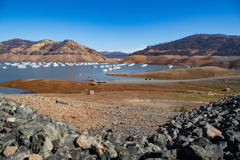
Oroville Dam Citizens Advisory Commission Public Meeting
The California Natural Resources Agency is hosting its ninth Oroville Dam Citizens Advisory Commission meeting on Dec. 3, 2021, from 10 a.m. – 12 p.m. The public meeting will be held online and will include presentations and public comment. The commission will receive an overview of downstream flood management and preparedness as well as an update on the Water Control Manual from a representative of the U.S. Army Corps of Engineers. The Citizens Advisory Commission is a forum to provide public feedback from the communities surrounding Oroville Dam. For information on how to join the virtual meeting, please visit https://bit.ly/OrovilleCAC.
Lake Oroville Boating
Bidwell Canyon’s Stage III concrete boat ramp is now open to boaters. Water elevations at Lake Oroville have benefited from recent precipitation events, pushing lake levels above the bottom of the ramp. The single-lane gravel boat ramp at Oroville Dam’s Spillway Boat Ramp area will continue to be open as conditions permit.
The California Department of Parks and Recreation (State Parks) order prohibiting nighttime boating is no longer in effect. As always, boaters on the lake are advised to be aware of unexpected shallow water, obstruction hazards, and floating debris.
Access to boats and houseboats at both Bidwell Canyon and Lime Saddle marinas should be coordinated through the marina prior to arrival by calling (530) 589-9175 or by utilizing the shuttle service at Bidwell Canyon Marina. Shuttle services to Lime Saddle Marina is not being provided at this time. The Thermalito Afterbay and Thermalito South Forebay continue to be open to power boating.
Lake Oroville Visitor Center
The Lake Oroville Visitor Center is now open to the public on Tuesdays, Wednesdays, and Thursdays from 9 a.m. to 5 p.m. Visitors can tour the center’s exhibits on the construction of Oroville Dam – the tallest dam in the country; the State Water Project which provides water to 27 million Californians and 750,000 acres of farmland; a new interactive water education exhibit, and much more.
The visitor center also has a theater featuring videos on local topics and places, such as Oroville Dam and the Feather River Fish Hatchery, as well as walking and hiking trails showcasing local flora and fauna. A highlight of the visitor center is the 47-foot-high observation tower providing unsurpassed panoramic views of the lake, valley, foothills, Sierra Nevada range, and the Sutter Buttes - the smallest mountain range in the world.
Visitor center guides are available to provide tours of the facility to groups and classrooms. Previously provided tours of the Feather River Fish Hatchery are not available while the main hatchery is closed to the public. The nearby Fish Barrier Dam overlook, fish ladder, and underwater viewing window - all with interpretive signage - remain open to the public. Please contact the VC Guides at (530) 538-2219 for more information.
Loafer Creek Fuels Management
DWR, CAL FIRE, and California Department of Parks and Recreation (State Parks) partner on DWR’s Fuel Load Management Plan and CAL FIRE’s Vegetation Management Plan to reduce wildfire risk and increase public safety around the FERC project boundary, including Lake Oroville.
Over the next several weeks, crews from California Conservation Corps, Butte County Sheriff Office, and CAL FIRE’s Butte Fire Center will be performing various fuel reduction projects using heavy equipment, hand cutting, chipping, and burning of prioritized overgrown vegetative areas within the FERC project boundary. Trail users and visitors to the area and motorists along Highway 162 are advised to be mindful of safety when near work zones.
With help from area partners, approximately 840 acres have been manually thinned, re-thinned, grazed, and/or treated with prescribed fire since November 2012. DWR’s goal is to treat 150 acres this season.
Lakeside Access Road Construction
The Lakeside Access Road project is underway and expected to continue through January. This project will consist of a new, permanent, paved road from the west side of Oroville Dam to the Spillway Boat Ramp parking lot on the “lakeside,” or waterside, of the Oroville Dam spillways. This new road will allow a more direct route when water levels are low in Lake Oroville. The new road will include two concrete traffic lanes, wide shoulders for walking and biking, guardrails, and safety signage. Additionally, the contractor will be removing and replacing deteriorating asphalt from the Stage I Spillway Boat Ramp.
Visitors to Oroville Dam can expect to see large construction equipment and material deliveries in the area through January as the contractor works to complete the project. Please use caution and respect the construction fencing and safety signage when visiting Oroville Dam.
Oroville Recreation
Numerous Day Use Area (DUA) facilities with picnic tables and restrooms at Lake Oroville State Recreation Area (LOSRA) are open 8 a.m. to sunset. Bidwell, Lime Saddle, and Loafer Creek recreation areas are open 24 hours. The Oroville Dam Crest Road across Oroville Dam is available 5 a.m. to 11 p.m. daily with the Spillway trailhead and boat launch open from 6 a.m. to 8 p.m. The top of the dam is open to pedestrians and bicyclists 24-hours a day.
DWR’s new trail maps of over 97 miles of trails available to equestrians, bicyclists, and hikers wishing to explore Oroville’s natural beauty in the cooler fall weather are available at many Oroville locations including Lake Oroville State Recreation Area (LOSRA) kiosks, Oroville Wildlife Area office on Oro Dam Boulevard West, the Oroville Area Chamber of Commerce, and Feather River Recreation and Parks District.
Visit the California Parks LOSRA webpage for current information on facility status and campground reservations. An interactive map of recreation facilities in DWR’s Oroville-Thermalito Complex is available on DWR’s Lake Oroville Recreation webpage. Information about the 11,000-acre Oroville Wildlife Area is available on the California Department of Fish and Wildlife webpage.
Current Lake Operations
The elevation of Oroville’s reservoir is about 667 feet elevation and storage is about 1 million acre-feet, which is 29 percent of its total capacity and 57 percent of historical average. Lake Oroville continues to show incremental storage gains. The current forecast indicates mainly dry conditions through next week. Temperatures will range in the low-70s this weekend, then low to mid-60s next week.
Total flows to the Feather River are at 950 cubic feet per second (cfs) for meeting downstream water quality and flow requirements. Flow in the low-flow channel, through the City of Oroville, is 650 cfs and flow through the Thermalito Afterbay Outlet is 300 cfs. Releases are assessed daily and continued release reductions are expected to conserve water.
The public can track precipitation, snow, reservoir levels, and more at the California Data Exchange Center at www.cdec.water.ca.gov. Lake Oroville is identified as “ORO”.
All data as of midnight 11/11/2021