Snow Surveys

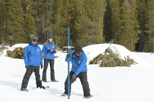
Department of Water Resources staff at the January 2020 snow survey. DWR/2020
Established in 1929 by the California Legislature, the California Cooperative Snow Surveys (CCSS) program is a partnership of more than 50 state, federal, and private agencies. The cooperating agencies not only share a pool of expert staff but share in funding the program, which collects, analyzes and disseminates snow data from more than 265 snow courses and 130 snow sensors located throughout the Sierra Nevada and Shasta-Trinity mountains.
California is the only western state to perform this function on its own. In the other western states, snow surveys are done by the federally funded Natural Resources Conservation Service, which began its program in the mid-1930s. Both programs are similar, and there is a high degree of cooperation between the two entities.
DWR is the lead agency in coordinating the CCSS program, which includes:
- Maintaining snow surveying and sampling equipment
- Training for our partner agencies
- Course measurement schedules and data collection
- Fiscal and staff resource needs for the various partners within the program.
The CCSS program also forecasts seasonal and water year runoff for the major snow bearing watersheds in California. Water supply forecasts in the Bulletin 120: Water Conditions in California series are vital for planning and managing the state's water resource systems to benefit all Californians.
Highlights from this winter's media-oriented snow survey at Phillips Station are available below.
April 2020: (DWR staff only; no media due to the coronavirus pandemic)
- Snow survey result highlights
- Results of Phillips Station Snow Survey (video)
- Digital photos of past Phillips surveys
- California Cooperative Snow Surveys Program Story Map: https://arcg.is/1fiCbG
- Snowpack readings (View readings for current regional snowpack and historical snowpack comparison)
March 2020:
February 2020:
January 2020:
Avalanche and Travel Resources:
- Bridgeport Avalanche Center (Sonora Pass): Snowpack summaries and avalanche warnings for the Bridgeport Winter Recreation Area.
- CaltransQuickMap: Road conditions and travel alerts.
- Eastern Sierra Avalanche Center: Regular avalanche and snowpack updates for Eastern Sierra Nevada visitors.
- Mount Shasta Avalanche Forecast: Avalanche advisories and warnings for Mount Shasta.
- Sierra Avalanche Center: Backcountry avalanche, snow, and weather information for the greater Lake Tahoe area.
Snow Analyses and Research:
- California Cooperative Snow Surveys: Program background, data collection, snow survey, and procedure information.
- NASA Airborne Snow Observatory: Snow water equivalent and snow albedo data from research conducted by NASA/JPL in partnership with DWR.
- National Operational Hydrologic Remote Sensing Center: National Snow Analyses. Maps of snow water equivalent, snow precipitation, snow melt, and other reports.
- Natural Resources Conservation Services: SNOTEL Data. Snow Telemetry (SNOTEL) daily and hourly data reports.
- Western Snow Conference: Forum for individuals and organizations to share information on snow and runoff and to advance snow and hydrologic sciences.
The California Data Exchange Center is a repository of snow, precipitation, and hydrology data. The charts, maps, and tables listed below are some of the most frequently used. Additional precipitation and snow sensor reports are available on CDEC.
Charts:
- California Snow Water Content (Percent of April 1 Average): PDF chart for Northern, Central, and Southern Sierra snow water content showing average, minimum, maximum and current for the water year. Interactive chart option also available.
- Northern Sierra Precipitation: 8-Station Index: PDF chart for the 8-station index for the current water year. Interactive chart option also available.
- San Joaquin Precipitation: 5-Station Index: PDF chart for the 5-station index for the current water year. Interactive chart option also available.
- Tulare Basin Precipitation: 6-Station Index: PDF chart for the 6-station index for the current water year. Interactive chart option also available.
Maps:
- Flood Emergency Response Information Exchange (FERIX): Snow Surveys page: Interactive map of snow sensors that provides snow water equivalent, sensor history, precipitation, and temperature information.
- Snow Water Equivalents: Interactive map of snow water equivalents for the Northern, Central, and Southern Sierra, including a statewide summary. Provides printable PDF.
- Statewide Summary of Snow Water Content: Map shows percentage of April 1 average and of normal for current date for the Northern, Central, and Southern Sierra.
Tables:
- Basin Summary of Full Natural Flows (Water Year): Monthly summary of flows from river basins.
- Daily Full Natural Flows for Current Month: Daily summary of flows from selected river basins.
- Daily Precipitation Stations: Index of stations organized by river basin from north to south. Click on station name to view and download data.
- Daily Snow Sensor Report: Data for selected automatically reporting snow gage sensors.
- Runoff Data for Current Water Year: Unimpaired runoff data by hydrologic region with comparisons to 50-year average.
- Snow Course Measurements: Index of stations organized by river basin from north to south.
- Snow Water Equivalents (updated daily): Table of snow water equivalents for the Northern, Central, and Southern Sierra, including a statewide summary.
Documents
- Bulletin 120 Water Conditions in California
- History of the Snow Surveys Program
- Presentations and Agendas from the Annual Meeting of the California Cooperative Snow Surveys Program
- Story Map about the Snow Surveys Program
- Water Supply Index (WSI) Forecasts for Sacramento (SRR and SVI) and San Joaquin (SJI) Rivers
Contact Information
Subscribe to the Water Supply Forecast Newsletter
Subscribe to our newsletter for forecasts of seasonal runoff and summaries of precipitation, snowpack, reservoir storage, and runoff throughout California. It is sent out from February through June each year. Past editions are available on CDEC.
