Weirs on the Sacramento River: 100 Years of Flood Control
A drone photo shows the Fremont Weir along the Sacramento River overtopping in the wake of an atmospheric river in California. Photo taken February 6, 2024.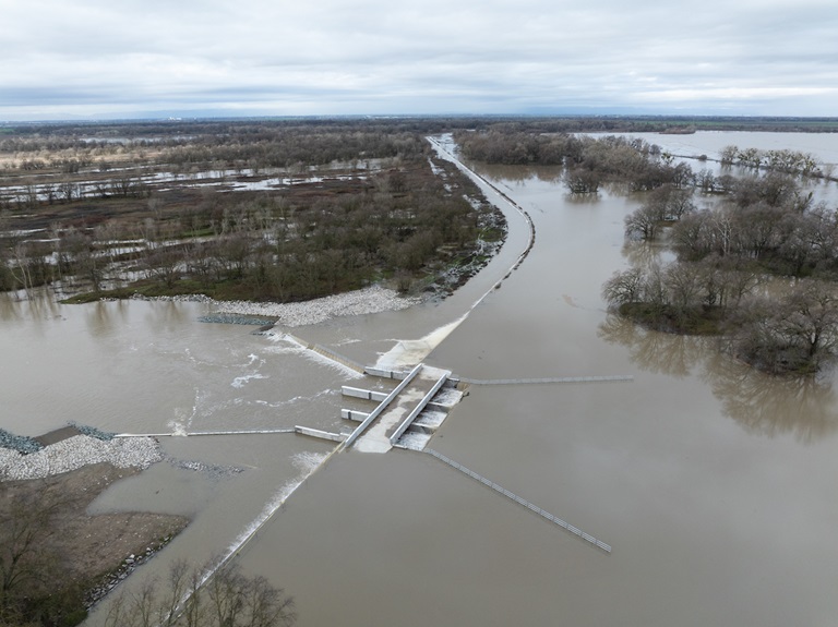
Set into the banks of the Sacramento River as it winds its way south from its Mount Shasta headwaters are six large concrete structures which, despite their size, go largely unnoticed until the rains come and the river rises, threatening floods. Then they get to work, channeling the deluge into bypasses and basins, and away from the levees and bridges of Sacramento and other downstream communities. These unobtrusive structures, called weirs, are distributed along a 95-mile stretch of the river from Butte City to North Sacramento, acting as silent sentinels protecting millions of Californians from flooding.
During Sacramento’s centuries-long history of battling flood waters, inhabitants have devised nearly every possible method of slowing or diverting water. Today, roughly 1,115 miles of levees protect farms and communities in and around the Sacramento-San Joaquin Delta, a crucial conduit for California’s overall water supply. However, the Delta’s levees are vulnerable to failure due to floods, earthquakes and rising sea levels brought about by climate change. A widespread levee failure could imperil the state’s water supply. Consequently, the impacts of flooding from the Sacramento River could extend far beyond the river and its surrounding basins.
“This system of weirs and bypasses is the backbone of the Sacramento River Flood Control Project,” said Manager of DWR’s Division of Flood Management Jeremy Arrich. “When these weirs are flowing, they’re taking pressure off the main stem levees and moving that water into the bypass system to flow safely downstream.”
A typical weir is a small barrier built across a stream or river that allows water to pool behind it and flow over it in a steady and controlled manner, controlling the height of the river level to prevent flooding. The six weirs on the Sacramento River, however, work in a different way. Rather than spanning the river, they are built into lowered sections of levees and are designed to allow flood flows in excess of the downstream channel capacity to escape into a bypass channel or basin.
Five of these overflow structures, the Moulton, Colusa, Tisdale, Fremont, and Cache Creek weirs, are referred to as “passive” weirs which allow floodwaters to spill over them once the river level exceeds their height. The Sacramento Weir is a more complex structure that has 48 gates on top of the overflow section that hold back floodwaters until opened manually by the Department of Water Resources’ Division of Flood Management. This is a rare event that only occurs if the height of the Sacramento River reaches 29.87 feet at the I Street Bridge and the forecast is for it to continue to rise. The last time this occurred was in January 2017, when significant rainfall swelled the Sacramento River and threatened to cause levee breaches.
The Sacramento- River’s six weirs are, from north to south:
- The Moulton Weir, completed in 1932, is located along the easterly side (left bank looking downstream) of the Sacramento River approximately eight miles north of the town of Colusa and about 100 miles north of Sacramento. Its primary function is to release overflow waters of the Sacramento River into the Butte Basin at times when floods exceed the safe carrying capacity of the main channel of the Sacramento River downstream from the weir.
- Further south, the Colusa Weir also empties into the Butte Basin.It was completed in 1933 and is located along the left bank of the Sacramento River one mile north of the town of Colusa.
- The Tisdale Weir, completed in 1932, is located along the left bank of the Sacramento River about ten miles southeast of the town of Meridian and about 56 miles north of Sacramento. Its primary purpose is to release overflow waters of the Sacramento River into the Sutter Bypass via the Tisdale Bypass.
- The Fremont Weir, constructed in 1924, is the first overflow structure on the river's right bank, at the beginning of the Yolo Bypass. It is located about 15 miles northwest of Sacramento and eight miles northeast of Woodland. South of this location, the Yolo Bypass conveys 80 percent of the system’s floodwaters through Yolo and Solano Counties until it connects to the Sacramento River a few miles upstream of Rio Vista.
- The Cache Creek Weir and Settling Basin were originally completed between the late 1930s through the early 1950s. The basin was expanded, and the new weir was completed in 1991. It is located in Yolo County about two miles east of the City of Woodland. Its primary purpose is to preserve the floodway capacity of the Yolo Bypass by trapping the heavy sediment load carried by Cache Creek before its waters pour into the bypass.
- The Sacramento Weir, the only weir that is operated manually, was completed in 1916. It is located along the right bank of the Sacramento River approximately 4 miles upstream of the Tower Bridge, and about 2 miles upstream from the mouth of the American River. Its primary purpose is to protect the City of Sacramento from excessive flood stages in the Sacramento River channel downstream of the American River. Measuring 1,920 feet long, it consists of 48 gates that divert Sacramento and American River floodwaters to the west down the mile-long Sacramento Bypass to the Yolo Bypass. Flood forecasters provide the necessary predictive information to weir operators who manage the number of opened gates in order to control the river's water surface elevation.
To help preserve the Sacramento Weir for the next 100 years, the U.S. Army Corps of Engineers has funded a $350 million expansion project to widen the 1,950-foot weir with an additional 1,500 feet at its northern end. The weir’s manually operated gates will remain intact. The expansion entails the construction of an additional passive weir which will allow floodwaters to flow into the Yolo Bypass without operation of gates. The gated portion of the weir will remain intact but will be operated less frequently, only opened when needed during more severe flood events. The Corps, Central Valley Flood Protection Board, DWR and the Sacramento Area Flood Control Agency broke ground on the Sacramento Weir expansion project in 2023 and estimate that the project will be completed by December 2026.
Warming temperatures resulting from a changing climate have increased the amount of precipitation that falls as rain rather than snow, leading to an increase in peak flows of rivers earlier in the year. Climate models also indicate that the atmospheric river storms that have brought catastrophic floods to California recently, will increase in frequency and intensity in the coming years. These additional challenges for flood risk management in California will guarantee that the time-tested Sacramento River weirs will continue to be called upon to provide the first line of defense against the threat of inundation for communities throughout the state.