DWR’s Innovative Underground Aquifer Mapping Project Reaches Major Milestone: Data Now Available for Entire Central Valley
On the left, a helicopter transporting Airborne Electromagnetic Survey (AEM) survey equipment is seen at a media event held at the Yolo County Airport on April 25, 2022. On the right, the online AEM Data Viewer provides a quick and easy way to visualize AEM data on this statewide map application.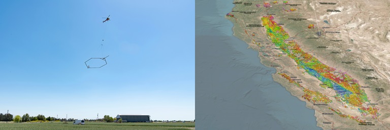
The Department of Water Resources’ (DWR) innovative Statewide Airborne Electromagnetic (AEM) Survey Project has now released AEM data for the entire Central Valley of California, marking a major milestone for the program.
Over 11,500 line-miles of AEM data were collected within the Central Valley between December 2021 and May 2022 using this helicopter-based technology that scans the earth’s subsurface. The AEM data is published on a continual basis, and the most recent release of data from the Northern Sacramento Valley completes the data release for the entire Central Valley. This remarkable dataset provides a never-before-seen continuous view of the structure below the earth’s surface in one of the most groundwater-dependent areas of the world.
The State is fast-tracking investments in the latest technology, like AEM, to ensure we are prepared for the weather extremes that are playing out in the new climate reality. AEM data is vital in providing local agencies and the State with a better understanding of the complex underground aquifer systems in California. This data is invaluable for identifying the most suitable locations to implement groundwater recharge projects that can capture water from extreme rain events like we have just seen, and store that water for use during dry periods.
“As California adapts to a new normal of climate extremes, we recognize that local groundwater sustainability agencies are going to have to adjust their groundwater sustainability plans over time to incorporate effects of extended dry periods and intense rain events,” said Paul Gosselin, Deputy Director of DWR’s Sustainable Groundwater Management Office. “DWR provides technical support to local agencies, including this vital AEM data, to help them reach their sustainability goals.”
DWR’s Statewide AEM Surveys
As a part of the Statewide AEM Survey Project, DWR is collecting AEM data in all high- and medium-priority groundwater basins in California, where data collection is feasible. The goal of the project is to improve the understanding of large-scale aquifer structure and support local development of Groundwater Sustainability Plans (GSP) and implementation of the Sustainable Groundwater Management Act (SGMA).
Benefits of the Statewide AEM Survey Project include:
- Providing a standardized, statewide dataset that improves the understanding of groundwater aquifer structures and groundwater basin hydrogeology
- Helping local groundwater sustainability agencies (GSAs) further develop and refine hydrogeologic conceptual models and groundwater models that are required elements in GSPs
- Helping local agencies determine areas in their basins where additional, more targeted surveys may be beneficial to fill data gaps
- Helping local agencies determine the best places to locate groundwater recharge projects, and other projects that support long-term groundwater sustainability and water supply resilience
- Providing this data to local agencies saves them the time and expense needed to gather this data themselves, and they can dedicate those resources instead to local projects and management actions that will help them reach their sustainability goals.
The replenishment of depleted groundwater basins is a key action that GSAs are implementing to reach sustainability, and an essential part of California’s long-term water resilience and drought mitigation efforts, as seen in Governor Gavin Newsom’s strategy document, “California’s Water Supply Strategy, Adapting to a Hotter, Drier Future,” which was released last summer. Local agencies must be ready to capture significant rainfall and flood flows for groundwater recharge when rain events come. Data obtained from DWR’s AEM survey program helps state and local agencies find the best places to put groundwater recharge projects where they will provide the most benefit, making project implementation efficient and effective.
DWR does this work in coordination with GSAs, and state and federal agencies -- getting input on areas of interest prior to finalizing survey flight lines. This ensures the data collected is multi-benefit and supports a wide range of groundwater and geology related project types. DWR also engages with GSAs, practitioners, academia, and technical experts from across the U.S. and internationally through a Technical Advisory Committee (TAC). Engagement with the TAC ensures that the project is consistent with state-of-the-science practices and that the project goals meet GSA and practitioner needs.
The AEM data is made publicly accessible and can be viewed on DWR’s AEM Data Viewer. This online, GIS-based tool displays AEM data in a three-dimensional space and allows the user to interact with the data by zooming and viewing the data from various angles. The tool can be accessed on a computer or mobile phone and does not require data to be downloaded or the use of specialized software. AEM data, and supporting data like newly digitized well lithology logs and geophysical logs (e-logs), can also be accessed on the California Natural Resources Agency Open Data Platform.
Upcoming Surveys
DWRs AEM surveys began in summer 2021 and surveys have already been conducted throughout the Central Valley, Salinas Valley, Monterrey Bay Area, North San Francisco Bay Area, and Northern California. The surveys are planned to continue through 2023 and into 2024 with data being collected in the San Luis Obispo and Santa Barbara County Areas, Southern California, and the Salton Sea Area. The survey schedule is available online at AEM Survey Schedule.
The surveys are funded by voter-approved Proposition 68, Senate Bill 5, and from the State’s general fund. More information can be found in the AEM Proposition 68 Fact Sheet.