25 Years After Deadly 1997 New Year’s Floods, Here’s How California is More Prepared
The massive Northern California flood in early January 1997, forced a break in the west levee of the Sutter Bypass near McClatchy Rd. inundating much of Reclamation District No. 1660 and District 70, within Sutter County. DWR/1997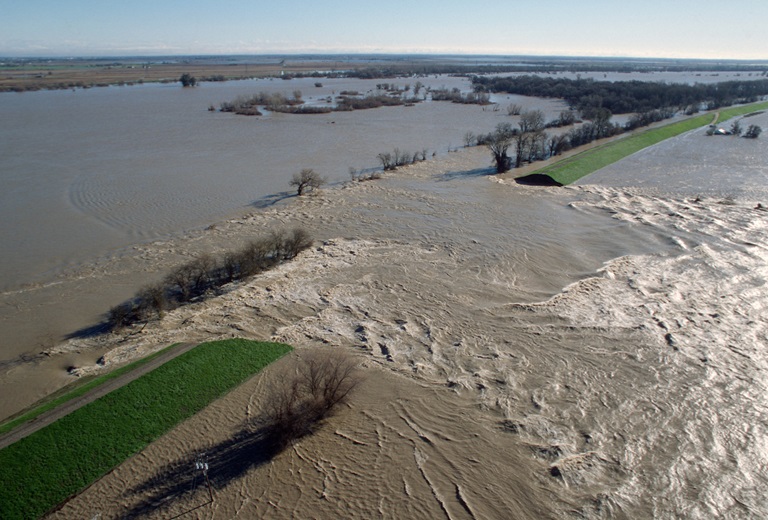
California is no stranger to devastating floods. With the most variable weather conditions in the country, the state receives between 40 and 60 percent of its precipitation from atmospheric rivers, a stream of water vapor created in the atmosphere by circulating air currents over the waters of the Pacific Ocean.
As the calendar turned from 1996 to 1997, these storms walloped California, leading to deadly flooding and billions of dollars in economic damage.
The series of storms, what used to be called a “pineapple express”, funneled an atmospheric river from the warm waters near Hawaii to the California foothills. Releasing only some of its moisture in the Central Valley, it drenched the Sierra foothills -- up to 40 inches in some locations.
Multiple rivers and flood channels experienced levee failures, from the Truckee and Feather rivers, as well as the Sutter Bypass in the north, to the Cosumnes, Tuolumne, San Joaquin, and Merced rivers to the south. The result was breached levees, flooded farmland, and inundated towns and highways up and down California’s Sacramento and Central valleys.
In the years since, DWR has made significant improvements in data collection, flood risk assessments, flood planning, flood project implementation (levee infrastructure), operations and maintenance, floodplain management, emergency response, forecasting, , and reservoir operations. The Department has collaborated with multiple partners to improve California’s ability to predict, prepare for, and respond to atmospheric river storms that cause flood events like the one in 1997.
Improving our Ability to Predict and Manage the Next Storm
Predicting the arrival and intensity of atmospheric rivers has long been a challenge for weather scientists. The ability to forecast variable weather conditions in advance is a driving factor in how water managers maximize the benefits and minimize the hazards of each storm.
In 2019, DWR joined with the Yuba Water Agency and the University of California San Diego’s Scripps Institution of Oceanography’s Center for Western Weather and Water Extremes in a research initiative called “Forecast Informed Reservoir Operations”, or FIRO, to significantly reduce flood risk in the Yuba-Feather River Basin.
By aligning the operations of Oroville Dam on the Feather River and New Bullards Bar Dam on the Yuba River, water operators can improve flood risk management by creating more flood detention storage in reservoirs ahead of big storms, while also improving future water supply storage.
“By engaging together with science, academic and governmental partners in the pursuit of emerging forecasting technologies, as well as building flood protection improvements and coordinating closely when storms arrive, we are able to reduce flood risks in the Yuba-Feather Basin,” said DWR Director Karla Nemeth.
New technologies like Airborne Snow Observatory observations are being utilized by DWR hydrologists responsible for water supply forecasts.
In addition to installing more accurate devices at weather monitoring stations across the Sierra, new methods of collecting data on Sierra snowpack conditions include using airborne Light Detection and Ranging (LIDAR) surveys to provide detailed data, especially in remote areas normally inaccessible to manual snow surveys. With California’s snowpack providing critical snowmelt to fill reservoirs during the state’s dry summer months, access to accurate data is critical.
How to Protect Lives, Property and Habitat from Flooding
Reports written after the 1997 New Year’s flood produced more than 50 recommendations to improve California’s resilience to flood events, with many addressing the need to improve the state’s flood management systems.
“Working with a variety of partners throughout the state, DWR and our local and federal partners have invested billions of dollars to improve flood management systems across the state”, said Jeremy Arrich, manager of the Department’s Division of Flood Management.
DWR grant programs have provided financial assistance to improve levees, channels, flood control structures, and floodplains that help protect lives, property, and wildlife habitat, ultimately reducing damages when higher category atmospheric rivers result in flood events.
As climate change increases the occurrence of weather extremes, including more intense precipitation events, multi-benefit projects to restore and improve natural systems of flood management while facilitating habitat restoration are also being constructed by DWR and its partners.
A list of DWR-led levee setback projects, which create a larger floodplain area when rivers overflow their banks and projects to restore wetlands, can be found on DWR’s EcoRestore webpage.
Public education about flood preparedness helps Californians be informed about flood risk and how to be ready. Outreach includes areas affected by wildfire to remind residents of the greater risk of flood and debris flow in burn scar areas.
Responding to Flood Events
The Governor’s Flood Emergency Action Team report on the 1997 flood event included recommendations to improve emergency response actions. Many of these actions addressed the need for federal, state, and local emergency responders to improve communication and coordination with local agencies that maintain levees and flood control structures, city and county emergency management agencies, and agencies responsible for reservoir operations.
In 2005, DWR and Yuba Water Agency (YWA) initiated the Forecast-Coordinated Operations (F-CO) Program with support from the U.S. Army Corps of Engineers and the National Weather Service/California-Nevada River Forecast Center (CNRFC). The goal of the F-CO Program is to coordinate flood releases from reservoirs to better protect life, properties, and ecosystems for downstream communities, without impacting facilities’ water supplies. In 2008, the F-CO Program was expanded to include reservoirs in the San Joaquin River Basin. The work of the F-CO Program laid the foundation for the new forecast and operations methodology FIRO.
DWR’s Flood Operations team partners with local, state, and federal agencies to prepare to respond to flooding. Before flood seasons begin, the group ensures there are open lines of communication between organizations and provide flood flight training and access to critical data and tools.
DWR remains committed to reducing flood risks, even during the state’s current drought. The Department manages the State-Federal Flood Operations Center and has nearly 250 staff on emergency rosters that could be called onto the front lines of response when floods occur. We also provide funding, support, planning, and project construction, and are embracing new technologies and collaborations like F-CO and FIRO.
More information on the 1997 New Year’s floods:
Photo Essay: 1997 New Year’s Floods in NorCal
Yuba Water Agency: 25 Years Since the New Year’s Floods of 1997 in Yuba County