Lake Oroville Community Update - July 17, 2020
Boaters on Lake Oroville. DWR/2019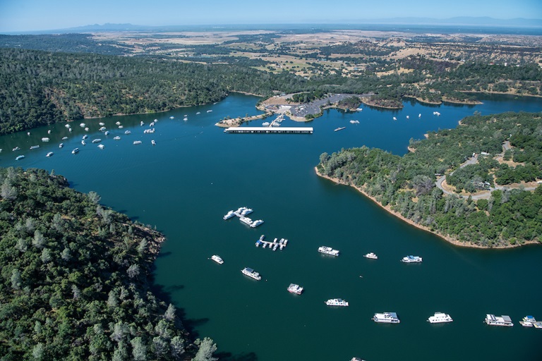
Oroville Recreation Update
Lake Oroville and the North and South Forebay boat ramps, parking lots, and day use areas are open. Except for the Oroville Dam Spillway Boat Ramp area, which is open daily, 5 a.m. to 11 p.m., Lake Oroville State Recreation Area (LOSRA) boat ramps are open 24 hours a day, seven days a week. Trails and Day Use Areas are open from 8 a.m. to sunset. Floating campsites and group campsites are not currently available to reduce the spread of COVID-19. For information about State Parks camping, as well as COVID-19 public health requirements while recreating, visit www.parks.ca.gov/COVID19Camping.
The Oroville Wildlife Area, including the Thermalito Afterbay, is open 1.5 hours before sunrise to one hour after sunset and offers miles of trails and wildlife viewing. The Forebay Aquatic Center at the North Forebay Recreation Area is open Friday through Sunday 10 a.m. to 7 p.m. for boat, kayak, and other aquatic equipment rentals. Information and an interactive map of Lake Oroville and OWA recreation facilities is available on the Department of Water Resources (DWR) Lake Oroville Recreation webpage. The Lake Oroville Visitors Center remains closed due to COVID-19.
Oroville Area Algal Blooms Status
DWR environmental scientists regularly monitor Lake Oroville, the Thermalito North Forebay, and the Thermalito Afterbay for cyanobacteria (blue-green algae) and their toxins. There are currently no Harmful Algal Bloom (HAB) advisories for Lake Oroville, the Thermalito Forebay, or the Thermalito Afterbay.
Algal blooms have been identified in the West Branch and the North Fork of Lake Oroville. Lab analysis of water samples from these water bodies found minimal or no amounts of cyanobacteria. Sampling continues weekly and if elevated levels of cyanobacteria or toxins are found, DWR staff will work with California’s Regional Water Quality Control Board and recreation area managers to notify the public and post advisory signs at the affected waterbody. Non-toxic algal blooms can be irritating or even dangerous to pets and small children. To learn more about HABs, visit the Water Board’s website and DWR’s digital article on the DWR Updates webpage.
CAL FIRE to Reduce Fire Fuels Around the Forebay
The CAL FIRE/Butte County Fire Department, in cooperation with DWR and CA Parks, has scheduled a series of four control burns of about 245 acres of grassland for July 23 to 25. Areas around the North and South Forebay including near the North Forebay Aquatic Center, areas west of Nelson Field, near the South Forebay/Grand Avenue, and off Wilbur Road and Tres Vias Road are targeted. The exact dates and times will be determined by current fire weather and fire personnel activity.
These important vegetation management project (VMP) burns will clear the area around the Forebays of thick grass, which could easily ignite if left to grow. The burns also benefit vernal pool habitat by promoting native vernal pool vegetation. The project also offers valuable training for firefighters as we enter fire season. Smoke from these control burns will be visible in the area.
Feather River Water Flow Changes Help Fish
Persons recreating in the Feather River’s Low Flow Channel near Oroville (the area of the river between the Thermalito Diversion Dam and the Thermalito Afterbay River Outlet) may observe changes in the river’s elevation and rate of water flow as DWR works to meet water temperature environmental requirements for the river. Increasing the rate of water flow is one of the tools DWR uses to maintain suitable temperatures in the Feather River Low Flow Channel for steelhead and salmon. The water temperature is managed to not exceed 65 degrees throughout the summer, measured as a daily average, at Robinson Riffle which is located about five miles downstream from the Thermalito Diversion Dam.
Those recreating in the Feather River, including swimming, fishing, and boating, are encouraged to be aware of changes in currents and river elevations. Flows were increased Wednesday in the Low Flow Channel from 950 cfs (cubic feet per second) to 1,250 cfs, resulting in an approximate 2 to 3-inch increase in the river’s elevation.
Installation of Piezometers at Oroville Dam
DWR continues work to install four new piezometers at the headworks of Oroville Dam’s main, or flood control outlet (FCO), spillway. The piezometers will continuously collect data from the FCO foundation. The data will be used to confirm drain performance, inform on-going structural modeling and analyses, and to inform future improvements to the structure.
This work is part of early implementation of the Oroville Dam Safety Comprehensive Needs Assessment (CNA), which is focused on identifying priorities and appropriate solutions to bolster the integrity and resiliency of the Oroville Dam complex to ensure public safety. Over the next couple of weeks, scaffolding will be installed inside the gate structures to protect worker safety. Installation of the piezometers is anticipated to begin in early August.
A number of piezometers were originally installed in the dam fifty years ago which, as anticipated, have since stopped functioning. Including the four headworks piezometers, and the eight new piezometers installed earlier this year at the base of Oroville Dam, DWR continues its work to install additional instrumentation throughout the facility.
New Trail Signage Informs Area Visitors
DWR and CA Parks staff have installed new trail signposts and new trail marker icons in numerous locations around Lake Oroville and the Thermalito Diversion Pool to help area visitors identify the activity (hiking, biking and/or horseback riding) allowed on the trails. New signposts also provide directions to newly realigned trails with more sign and icon installations planned for other areas including the Oroville Wildlife Area.
The Oroville Facility Trail system features 91 miles of trails, with access to Lake Oroville, Thermalito Diversion Pool, Thermalito Afterbay, and Thermalito Forebay. The trails consist of an array of single track, fire roads, and paved trails which border beautiful natural areas, provide stunning views, and allow plentiful opportunities for wildlife viewing. Trail users can seasonally view salmon, grebes, loons, waterfowl, bald eagles, turkey vultures, snakes, frogs, and more throughout the trail network. Find area trails on the Lake Oroville Recreation webpage’s interactive map.
DWR Water Education Program Educates Youth Online This Summer
Missing Summer Camp? Join DWR’s virtual Summer Camp. DWR Staff will be providing fun activities relating to DWR’s recent Water Wednesday’s videos. The family-friendly programs are designed for kids 10 to 14 but are appropriate for anyone who would like to learn more about California’s water resources. Each video is available on DWR’s YouTube channel and a listing of all the program’s episodes can be found by clicking the Playlists tab. Activity suggestions and information can be found in the video’s comment section as they are added each week.
Current Lake Operations
The elevation of Oroville’s reservoir is about 782 feet and storage is about 2.0 million acre-feet. Daily average inflows to the lake have ranged between 1,048 cfs (cubic feet per second) to 1,620 over the past week.
Dry conditions and very warm temperatures continue this weekend and into the week of July 20. The Northern Sierra Basin rainfall totals remains below average for the year, at 63percent of normal.
The total releases to Feather River are 3,300 cfs to meet downstream Bay-Delta water quality and flow standards. Flows through the City of Oroville have increased to 1,250 cfs for fishery purposes. Flows from the Thermalito Afterbay Outlet (Outlet) are about 2,050 cfs for a total of 3,300 cfs for the Feather River’s high flow channel downstream of the Outlet.
All data as of midnight 7/16/2020