DWR Updates

Earthquake map

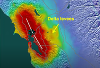
In the first of two Delta Conveyance Deep Dive episodes on seismic risks in the Sacramento-San Joaquin Delta, Laurence Sanati, head of the DWR Flood Systems Analysis Section, speaks about the potential consequences of a major earthquake in or near the Delta and the measures currently in place to deal with such an event.

Published:
Sensors at a monitoring station in the Feather River watershed

Every year, the Department of Water Resources (DWR) relies on data from monitoring stations strategically located across California to provide information that will aid the decision-making process regarding the flood control and water supply operations of California’s State Water Project (SWP).

Published:
A 2021 snow survey season event is conducted at Phillips Station in the Sierra Nevada Mountains. The survey is held approximately 90 miles east of Sacramento off Highway 50 in El Dorado County.  Photo taken April 1, 2021.

The first half of Water Year 2021 is over, and California’s wet season is almost finished. The first six months of the water year rank as the fourth driest of record based on statewide precipitation.

Published:
image of construction of the main Oroville spillway

In the first episode in the Delta Conveyance Team Spotlight video series, we spoke with the project’s Executive Director Tony Meyers about his long and eventful career in engineering, including work on some of DWR’s most ambitious and significant infrastructure projects.

Published:

Filters