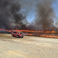
![A drone view of Bidwell Bar Bridge at Lake Oroville in Butte County, California.](/-/media/DWR-Images/Oroville/2024_09_05_AN_0031_Oroville_Lake_levels_DRONE.jpg?mw=200&hash=17FC2A6C32B58D379C802BEEA5C8484B)
DWR Updates
![A drone view of Bidwell Bar Bridge at Lake Oroville in Butte County, California.](/-/media/DWR-Images/Oroville/2024_09_05_AN_0031_Oroville_Lake_levels_DRONE.jpg?mw=200&hash=17FC2A6C32B58D379C802BEEA5C8484B)
![](/-/media/DWR-Images/Oroville/2023_09_23_FG_0403_Oroville_Salmon_Festival.jpg?mw=200&hash=1740931D20840B396AC4FA0C4A7750F6)
![A drone view of Oroville Dam and Lake Oroville in Butte County, California.](/-/media/DWR-Images/Oroville/2024_01_30_AN_0050_Lake_Oroville_Levels_DRONE.jpg?mw=200&hash=F8789D01653FB7CC107346AFD2FC3070)
![A section of the Brad Freeman trail near Garden Drive in Oroville is prepared for future paving work.](/-/media/DWR-Images/Oroville/20240815_082022.jpg?mw=200&hash=9C46FEE805DC42460A29F453008348EE)
![Logo for the ten year anniversary of the Sustainable Groundwater Management Act (SGMA).](/-/media/DWR-Images/Logos/SGMA-banner-logo-square.jpg?mw=200&hash=58A4F4D857EA9EA02C4F9473C7022EC7)
This year marks the tenth anniversary of the Sustainable Groundwater Management Act (SGMA).
Published:
![A drone view of Bidwell Canyon Marina and Bidwell Bar Bridge at Lake Oroville in Butte County, California. On this date, the water storage at Lake Oroville was 2,707,699 acre-feet (AF), 77 percent of the total capacity.](/-/media/DWR-Images/Oroville/2024_01_30_AN_0088_Lake_Oroville_Levels_DRONE.jpg?mw=200&hash=31E027B89CB7FB7ACF965DBAAD9BDF26)
![An aerial view shows high water conditions at the Bidwell Bar Bridge located at Lake Oroville in Butte County, California.](/-/media/DWR-Images/Oroville/2024_05_09_SN_1068_Lake_Levels_Aerial.jpg?mw=200&hash=0CC04FE12590BF641850AB9AE28B95B4)
![An aerial view shows high water conditions at Bidwell Canyon Marina located at Lake Oroville in Butte County, California.](/-/media/DWR-Images/Oroville/2024_05_09_SN_0954_Lake_Levels_Aerial.jpg?mw=200&hash=C3D9C5CA4DC1CE7B0F40E8107429F7AB)
![An aerial view shows high water conditions at West Branch Feather River Bridge located near the Lime Saddle Marina at Lake Oroville in Butte County, California. Photo taken May 9, 2024.](/-/media/DWR-Images/Oroville/2024_05_09_SN_0535_Lake_Levels_Aerial.jpg?mw=200&hash=881BBFA613BC5B942AEC2FD3DA39387B)
![Photo of one of the 15 side channels that make up the Upper Sacramento River Habitat Restoration project.](/-/media/DWR-Images/Rivers/Upper-Sacramento-River-Habitat-Restoration-Still.jpg?mw=200&hash=4196A7453BEC7DED1711DF7288F77EF2)
About 60 miles north of Chico, CA is Anderson River Park which sits along the Sacramento River, downstream from Shasta and Keswick dams. In 2015, this site became the target of a multi-pronged effort to restore 15 side channels along the Sacramento River to support native fish such as Chinook salmon.
Published: